Back مقاطعة بولك (أوريغون) Arabic پولک بؤلگهسی، اورقن AZB Polk County, Oregon BAR Полк (окръг, Орегон) Bulgarian পোল্ক কাউন্টি, অরেগন BPY Polk Gông (Oregon) CDO Полк (гуо, Орегон) CE Polk County (kondado sa Tinipong Bansa, Oregon) CEB Polk County, Oregon Welsh Polk County (Oregon) German
Polk County | |
|---|---|
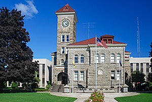
 Polk County Courthouse in Dallas | |
 Location within the U.S. state of Oregon | |
 Oregon's location within the U.S. | |
| Coordinates: 44°55′N 123°25′W / 44.91°N 123.42°W | |
| Country | |
| State | |
| Founded | December 22, 1845 |
| Named for | James K. Polk |
| Seat | Dallas |
| Largest city | Salem (portion) |
| Area | |
| • Total | 744 sq mi (1,930 km2) |
| • Land | 741 sq mi (1,920 km2) |
| • Water | 3.1 sq mi (8 km2) 0.4% |
| Population (2020) | |
| • Total | 87,433 |
| • Estimate (2023) | 89,805 |
| • Density | 118/sq mi (46/km2) |
| Time zone | UTC−8 (Pacific) |
| • Summer (DST) | UTC−7 (PDT) |
| Congressional district | 6th |
| Website | www |

Polk County is one of the 36 counties in the U.S. state of Oregon. As of the 2020 census, the population was 87,433.[1] The county seat is Dallas.[2] The county is named for James Knox Polk, the 11th president of the United States.
Polk County is part of the Salem, OR Metropolitan Statistical Area, which is also included in the Portland-Vancouver-Salem, OR-WA Combined Statistical Area. It is located in the Willamette Valley.
- ^ "State & County QuickFacts". United States Census Bureau. Retrieved May 15, 2023.
- ^ "Find a County". National Association of Counties. Retrieved June 7, 2011.
© MMXXIII Rich X Search. We shall prevail. All rights reserved. Rich X Search