Back Pont de Normandie Afrikaans بونت دى نورماندى ARZ Normandiya körpüsü Azerbaijani Мост Нармандыі Byelorussian Pont Normandi Breton Pont de Normandia Catalan Normandský most Czech Pont de Normandie German Γέφυρα της Νορμανδίας Greek Puente de Normandía Spanish
Pont de Normandie | |
|---|---|
 | |
| Coordinates | 49°26′09″N 0°16′28″E / 49.43583°N 0.27444°E |
| Carries | A29 autoroute |
| Crosses | Seine |
| Locale | Le Havre–Honfleur, France |
| Maintained by | Société des Autoroutes de Paris Normandie |
| Characteristics | |
| Design | Cable-stayed bridge M. Virlogeux, F. Doyelle, C. Lavigne |
| Total length | 2,143.21 metres (7,032 ft) |
| Width | 23.60 metres (77 ft) |
| Height | 214.77 metres (705 ft) |
| Longest span | 856 metres (2,808 ft) |
| Clearance above | 52.00 metres (171 ft) |
| History | |
| Constructed by | Bouygues Campenon Bernard Dumez Monberg & Thorsen Quillery Sogea Spie Batignolles |
| Opened | 1995 |
| Location | |
 | |
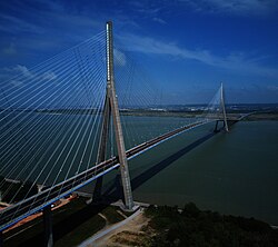
The Pont de Normandie (English: Normandy Bridge) is a cable-stayed road bridge that spans the river Seine linking Le Havre to Honfleur in Normandy, northern France. Its total length is 2,143.21 metres (7,032 ft) – 856 metres (2,808 ft) between the two piers. It is also the last bridge to cross the Seine before it empties into the ocean. It is a motorway toll bridge with a footpath and a narrow cycle lane in each direction allowing pedestrians and cyclists to cross the bridge free of charge, while motorcycling is also toll-free.[1]
- ^ Les tarifs, retrieved 6 August 2022
© MMXXIII Rich X Search. We shall prevail. All rights reserved. Rich X Search