Back Port Botany (Nouvelle-Galles du Sud) French פורט בוטאני HE Port Botany, New South Wales Malay Порт-Ботани (пригород) Russian
| Port Botany Sydney, New South Wales | |||||||||||||||
|---|---|---|---|---|---|---|---|---|---|---|---|---|---|---|---|
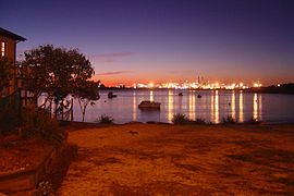
 View of Port Botany from La Perouse | |||||||||||||||
 | |||||||||||||||
| Population | 0 (SAL 2016)[1][2] | ||||||||||||||
| Postcode(s) | 2036 | ||||||||||||||
| Elevation | 2 m (7 ft) | ||||||||||||||
| Area | 2,345 km2 (905.4 sq mi) | ||||||||||||||
| Location | 12 km (7 mi) south of Sydney CBD | ||||||||||||||
| LGA(s) | City of Randwick | ||||||||||||||
| State electorate(s) | Maroubra | ||||||||||||||
| Federal division(s) | Kingsford Smith | ||||||||||||||
| |||||||||||||||
Port Botany is a suburb in the Eastern Suburbs of Sydney, in the state of New South Wales, Australia. Port Botany is located 12 kilometres south of the Sydney central business district, in the local government area of the City of Randwick. Port Botany sits on the northern shore of Botany Bay, adjacent to the suburbs of Matraville, Banksmeadow and Phillip Bay.
- ^ Australian Bureau of Statistics (27 June 2017). "Port Botany (suburb and locality)". Australian Census 2016.
- ^ Australian Bureau of Statistics (27 June 2017). "Port Botany (suburb and locality)". Australian Census 2016 QuickStats. Retrieved 28 June 2022.
© MMXXIII Rich X Search. We shall prevail. All rights reserved. Rich X Search