Back Portal:Afrika ALS بوابة:إفريقيا Arabic ܬܪܥܐ:ܐܦܪܝܩܐ ARC Portal:Afrika Azerbaijani Партал:Афрыка BE-X-OLD Портал:Африка Bulgarian دەروازە:ئەفریقا CKB Portál:Afrika Czech Portal:Afrika German Portal:Afrika DIQ

.svg)
Africa is the world's second-largest and second-most populous continent after Asia. At about 30.3 million km2 (11.7 million square miles) including adjacent islands, it covers 20% of Earth's land area and 6% of its total surface area. With 1.4 billion people0 as of 2021, it accounts for about 18% of the world's human population. Africa's population is the youngest amongst all the continents; the median age in 2012 was 19.7, when the worldwide median age was 30.4. Despite a wide range of natural resources, Africa is the least wealthy continent per capita and second-least wealthy by total wealth, ahead of Oceania. Scholars have attributed this to different factors including geography, climate, corruption, colonialism, the Cold War, and neocolonialism. Despite this low concentration of wealth, recent economic expansion and the large and young population make Africa an important economic market in the broader global context. Africa has a large quantity of natural resources and food resources, including diamonds, sugar, salt, gold, iron, cobalt, uranium, copper, bauxite, silver, petroleum, natural gas and cocoa beans, and tropical fruit.
Africa straddles the equator and the prime meridian. It is the only continent to stretch from the northern temperate to the southern temperate zones. The majority of the continent and its countries are in the Northern Hemisphere, with a substantial portion and a number of countries in the Southern Hemisphere. Most of the continent lies in the tropics, except for a large part of Western Sahara, Algeria, Libya and Egypt, the northern tip of Mauritania, and the entire territories of Morocco, Ceuta, Melilla, and Tunisia which in turn are located above the tropic of Cancer, in the northern temperate zone. In the other extreme of the continent, southern Namibia, southern Botswana, great parts of South Africa, the entire territories of Lesotho and Eswatini and the southern tips of Mozambique and Madagascar are located below the tropic of Capricorn, in the southern temperate zone.
Africa is highly biodiverse; it is the continent with the largest number of megafauna species, as it was least affected by the extinction of the Pleistocene megafauna. However, Africa also is heavily affected by a wide range of environmental issues, including desertification, deforestation, water scarcity, and pollution. These entrenched environmental concerns are expected to worsen as climate change impacts Africa. The UN Intergovernmental Panel on Climate Change has identified Africa as the continent most vulnerable to climate change.
The history of Africa is long, complex, and varied, and has often been under-appreciated by the global historical community. Africa, particularly Eastern Africa, is widely accepted to be the place of origin of humans and the Hominidae clade, also known as the great apes. The earliest hominids and their ancestors have been dated to around 7 million years ago, including Sahelanthropus, Australopithecus africanus, A. afarensis, Homo erectus, H. habilis and H. ergaster, the earliest Homo sapiens (modern human) remains, found in Ethiopia, South Africa, and Morocco, date to circa 233,000, 259,000, and 300,000 years ago, respectively, and Homo sapiens is believed to have originated in Africa around 350,000–260,000 years ago. Africa is also considered by anthropologists to be the most genetically diverse continent as a result of being the longest inhabited. (Full article...)
Selected article –

Swahili culture is the culture of the Swahili people inhabiting the Swahili coast. This littoral area encompasses Tanzania, Kenya, and Mozambique, as well as the adjacent islands of Zanzibar and Comoros along with some parts of Malawi and the eastern part of Democratic Republic of Congo. They speak Swahili as their native language, which belongs to the Bantu language family. Graham Connah described Swahili culture as at least partially urban, mercantile, and literate.
Swahili culture is the product of the history of the coastal part of the African Great Lakes region. As with the Swahili language, Swahili culture has a Bantu core that has borrowed from foreign influences. (Full article...)Featured pictures –
-
 Eswatini, formerly known as Swaziland, is a landlocked country in Southern Africa. The government is an absolute monarchy, the last of its kind in Africa, and the country has been ruled by King Mswati III since 1986. One of the country's important cultural events is Umhlanga, the reed-dance festival, held in August or September each year. This photograph shows Princess Sikhanyiso Dlamini, the eldest daughter of Mswati III, at the 2006 festival.
 -
 Photograph: Muhammad Mahdi KarimAdansonia digitata is a sub-Saharan African species of baobab tree. The genus, scientifically known as Adansonia, consists of nine species native to Madagascar, Africa, Arabia and Australia, and can reach heights of 5 to 30 m (16 to 98 ft) with trunk diameters of 7 to 11 m (23 to 36 ft).
 -

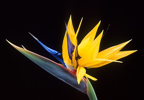
Bird of paradise flower Credit: USDAStrelitzia is a genus of five species of perennial plants, native to South Africa. It belongs to the plant family Strelitziaceae. The genus is named after Queen Charlotte of the United Kingdom. A common name of the genus is bird of paradise flower, because of a resemblance of its flowers to birds-of-paradise. In South Africa, it is commonly known as a crane flower and is featured on the reverse of the 50 cent coin. -
 Photograph: Sathyan VelumaniThe Larabanga Mosque was built in the Sudanese architectural style in the village of Larabanga, Ghana. It is the oldest mosque in the country and one of the oldest in West Africa, and has been called the "Mecca of West Africa". It has undergone restoration several times since it was founded. The World Monuments Fund has contributed substantially to its restoration, and lists it as one of the 100 most endangered sites.
 -
 Photo: NASAA composite satellite image of the geography of Africa, the Earth's second-largest continent, and its adjacent islands. Separated from Europe by the Mediterranean Sea and from much of Asia by the Red Sea, Africa is joined to Asia at its northeast extremity by the Isthmus of Suez. For geopolitical purposes, the Sinai Peninsula – east of the Suez Canal – is often considered part of Africa, although geographically it belongs in Asia. Africa can be divided into a number of geographic zones: The Atlas Mountains in the north, the Sahara, the coastal plains, and the inner plateaus.
 -
 Photograph: Poco a pocoPanoramic view of the Amphitheatre of El Jem, an archeological site in the city of El Djem, Tunisia. The amphitheatre, one of the best-preserved Roman ruins and a UNESCO World Heritage Site since 1979, was built around 238 AD, when modern Tunisia belonged to the Roman province of Africa. It is the third-biggest amphitheatre in the world, with axes of 148 m (486 ft) and 122 m (400 ft) and a seating capacity of 35,000, unique in Africa.
 -
 Photograph credit: Charles James SharpThe roan antelope (Hippotragus equinus) is a species of savanna antelope found in western, central and southern Africa. Named for its reddish-brown coat, it has a black face with white patches around the eyes and the mouth, and a short erect mane of greyish brown hair extending from the back of the neck to the rump. This roan antelope, of the subspecies H. e. koba, was photographed in Senegal; the subspecies's range extends from Senegal to Benin in western Africa.
 -
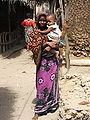
 Photo: William WarbyPortrait of a Maasai woman, with shaved head, stretched earlobes, and beaded adornments, typical of the Maasai culture. The Maasai are a Nilotic ethnic group of semi-nomadic people located in Kenya and northern Tanzania. They are among the best known of African ethnic groups, due to their distinctive customs and dress and residence near the many game parks of East Africa. Their primary language Maa (ɔl Maa) is a member of the Nilo-Saharan language family that is related to Dinka and Nuer.
 -

Ring-tailed Lemur holding twins born the previous night in Colchester Zoo, Essex, England Photo credit: NASA
The Sahara (Arabic: الصحراء الكبرى, aṣ-ṣaḥrā´, "The Great Desert") is the world's largest hot desert at over 9,000,000 square kilometres (3,500,000 sq mi). The Sahara defines the borders of North Africa and has an intermittent history that may go back as much as 2.5 million years. -
 Photograph credit: Charles J. SharpThe sable antelope (Hippotragus niger) is an antelope which inhabits wooded savanna in eastern and southern Africa, from the south of Kenya to South Africa, with a separate population in Angola. The species is sexually dimorphic, with the male heavier and about one-fifth taller than the female. It has a compact and robust build, characterized by a thick neck and tough skin, and both sexes have ringed horns which arch backward. The sable antelope has four subspecies.
This picture shows an adult male common sable antelope (H. n. niger) in the Tswalu Kalahari Reserve, South Africa. -

Pod of hippos in Luangwa Valley, Zambia Photo credit: Paul Maritz
The hippopotamus (Hippopotamus amphibius), from the Greek ‘ιπποπόταμος (hippopotamos, hippos meaning "horse" and potamos meaning "river"), is a large, mostly plant-eating African mammal, one of only two extant and three or four extinct species in the family Hippopotamidae. -
 Banknote: Swakopmund Bookshop (courtesy of the National Numismatic Collection, National Museum of American History)The South West African mark was a temporary currency issued in South West Africa between 1916 and 1918 as part of the South West Africa campaign. Issued after the conquest of German South West Africa by South Africa, notes were denominated in marks and pfennig, as with the withdrawn German South West African Mark. Many institutions issued banknotes; this two-mark note was issued by the Swakopmund Bookshop. The South-West African mark was replaced in 1918 by the South African pound.
 -

Lion in Namibia Photo credit: yaaaay
The lion (Panthera leo) is a mammal of the family Felidae and one of four "big cats" in the genus Panthera. The lion is the second largest feline species, after the tiger. The male lion, easily recognized by his mane, weighs between 150–250 kg (330–500 lb). Females range 120–150 kg (260–330 lb). In the wild, lions live for around 10–14 years, while in captivity they can live over 20 years. Though they were once found throughout much of Africa, Asia and Europe, lions presently exist in the wild only in Africa and India. -
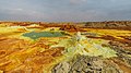 Photograph credit: Alexander SavinDallol is a cinder-cone volcano in the Danakil Depression, northeast of the Erta Ale Range in Ethiopia. The area lies up to 120 m (390 ft) below sea level, and has been repeatedly flooded in the past when waters from the Red Sea have inundated it. The Danakil Depression is one of the hottest places on Earth, and the evaporation of seawater after these flooding episodes produced thick deposits of salt, as seen in this landscape. The deposits at Dallol include significant quantities of the carbonate, sulfate and chloride salts of sodium, potassium, calcium and magnesium. Hot springs discharge brine to form the blueish ponds, and small, temporary geysers produce cones of salt.
 -

Morogoro Credit: Muhammad Mahdi Karim
Morogoro is a city with an urban population of 206,868 (2002 census) in the southern highlands of Tanzania, 190 km west of Dar es Salaam. It is the capital of the Morogoro Region. It is also known informally as "Mji kasoro bahari," which translates as 'city short of an ocean/port'. -

Nautical chart of Portuguese cartographer Fernão Vaz Dourado (c. 1520 - c. 1580), part of a nautical atlas drawn in 1571 and now kept in the Portuguese National Archives of Torre do Tombo, Lisbon. Photo credit: Portuguse National Archives of Torre do Tombo, Lisbon
A pre-Mercator nautical chart of 1571, from Portuguese cartographer Fernão Vaz Dourado (c. 1520 – c.1580). It belongs to the so-called plane chart model, where observed latitudes and magnetic directions are plotted directly into the plane, with a constant scale, as if the Earth were plane. The Moors from Spain had maps of the known world, and had been traveling to and from Mecca, Arabia for many years. In 1492, Christopher Columbus had possession of the Maps of the Moors, which had been confiscated from Andalusia and were now in service to Portuguese and Spanish Explorers. The African Moors already knew at that time, well into the 1500's, that the world was round. -

Tadrart Acacus Credit: Luca Galuzzi
Tadrart Acacus (Arabic: تدرارت أكاكوس) is a desert area in western Libya and is part of the Sahara. It is situated close to the Libyan city of Ghat. Tadrart means 'mountain' in the native language of the area (Tamahaq language). The Acacus has a large variation of landscapes, from differently coloured sanddunes to arches, gorges, rocks and mountains. Major landmarks are the arches of Afzejare and Tin Khlega. Although this area is one of the most arid of the Sahara, there is vegetation, such as the callotropis plant. The area is known for its rock-art and was inscribed as a UNESCO World Heritage Site in 1985 because of the importance of these paintings and carvings. -
 Photo credit: LaitcheThe Rose Geranium (Pelargonium graveolens) is a plant indigenous to various parts of southern Africa, and in particular South Africa. This specific species has great importance in the perfume industry. Its cultivars have a wide variety of smells, including rose, citrus, mint, coconut and nutmeg, as well as various fruits.
 -
 Banknote design credit: Deutsch-Ostafrikanische Bank; photographed by Andrew ShivaThe rupie was the unit of currency of German East Africa between 1890 and 1916. During World War I, the colony was cut off from Germany as a result of a wartime blockade and the colonial government needed to create an emergency issue of banknotes. Paper made from linen or jute was initially used, but because of wartime shortages, the notes were later printed on commercial paper in a variety of colours, wrapping paper, and in one instance, wallpaper. This five-rupie banknote was issued in 1915, and is now part of the National Numismatic Collection at the Smithsonian Institution.
Other denominations:
'"`UNIQ--templatestyles-00000013-QINU`"'


.jpg)
.jpg)


_adult_male.jpg)

.jpg)


.jpg)
Did you know (auto-generated) -

- ... that following the Report on the Restitution of African Cultural Heritage, the President of France promised to return African artworks looted during colonial times?
- ... that Ralph E. Brock was the first academically trained African-American forester in the United States?
- ... that Siphesihle November was brought to Canada from South Africa for ballet training at age 11, and became a principal dancer with the National Ballet of Canada at 22?
- ... that a former member of the French Senate ended up being exiled to the northern Central African Republic by the future emperor?
- ... that the sea urchin Pourtalesia miranda and the Venus flytrap sea anemone dominate the seabed community at a depth of 2,000 m (6,600 ft) off the coast of West Africa?
- ... that economist and anti-apartheid activist Vella Pillay arranged for South African revolutionaries to receive military training in the Soviet Union and China?
Categories

Selected biography –
Jean Verdi Salomon Razakandraina (1913–1978), commonly known as Dox, was a Malagasy writer and poet considered one of the most important literary figures in the country's history. He is principally renowned for his poetry and plays, but was also a painter, wrote and performed musical compositions, and translated several major French and English language works into Malagasy. His works have formed part of the language arts curriculum in Madagascar at every grade level since the country regained independence in 1960.
Dox began writing in 1930 while studying at a fine arts school in Antananarivo, where fellow students gave him the nickname "Dox". In 1932, after briefly conceding to his father's wish that he study medicine, Dox dedicated himself fully to the arts and joined with other notable Malagasy poets in advancing the Mitady ny very movement ("search for lost values"), launched by Jean-Joseph Rabearivelo, Charles Rajoelisolo and Ny Avana Ramanantoanina. His work during this period reflected the movement's aim to reaffirm the value of Malagasy identity, which had been eroded under the influence of the French colonial administration. In 1941, he printed his first collection of poems, Ny Hirako, which was written in the Malagasy language. When a major nationalist uprising erupted in 1947, Dox rallied behind the Mouvement démocratique de la rénovation malgache and suffered a gunshot wound during a protest. He also actively took part in the student protests of 1972 that brought down the Tsiranana administration. In 1971 he published his only compilation of French language poems, Chants Capricorniens. Throughout his career, he produced nine poem anthologies, numerous books in prose, and sixteen plays featuring folk tales, Biblical stories or Malagasy historical themes, in addition to countless privately commissioned works. (Full article...)Selected country –
 |
 |
|

| ||
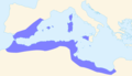
The Comoros (Arabic: جزر القمر, Ğuzur al-Qamar), officially the Union of the Comoros (French: 'Union des Comores', Arabic: الإتّحاد القمريّ, Al-Ittiḥād al-Qamariyy) is an island nation in the Indian Ocean, located off the eastern coast of Africa on the northern end of the Mozambique Channel between northern Madagascar and northeastern Mozambique. Prior to 2002, it was known officially as the Islamic Federal Republic of the Comoros. At 2,235 km² and with a population estimated at 798,000, the Comoros is the third smallest African nation by area and the sixth smallest by population.
The country officially consists of the four islands in the volcanic Comoros archipelago: Ngazidja (French: Grande Comore), Mwali (French: Mohéli), Nzwani (French: Anjouan), and Mahoré (French: Mayotte), as well as many smaller islands. However, the government of the Union of the Comoros (or its predecessors since independence) has never administered the island of Mayotte, which France considers an overseas community and still administers. (Read more...)
Selected city –

In the news
- 12 February 2024 –
- Two boats collide on the Congo River near Kinshasa, Democratic Republic of the Congo; with the death toll remains unclear. (AP)
- 11 February 2024 – 2023 Africa Cup of Nations
- In association football, hosts Ivory Coast win their third Africa Cup of Nations by defeating Nigeria 2–1 in the final. Sébastien Haller scores the winning goal in the 81st minute. (The Guardian)
- 10 February 2024 – Somali civil war
- Four Emirati soldiers and a Bahraini military officer are killed, while ten other people are injured, when a soldier opens fire at a military base in Mogadishu, Somalia, before being killed in the ensuing shootout. Al-Shabaab claims responsibility. (AP)
- 10 February 2024 –
- A Eurocopter EC130 helicopter crashes near Nipton, California, United States, killing all the six people on board, including Nigerian banker Herbert Wigwe. (CBS News)
- 10 February 2024 – 2023–2024 Senegalese protests
- Violent protests occur in Senegal following an announcement by President Macky Sall that presidential elections have been delayed from February 25 to December 15. (Sky News)
- 9 February 2024 –
- At least 18 people are killed during a collision between a bus and a truck on a road in Kinshasa, Democratic Republic of the Congo. (AP)
Updated: 16:33, 14 February 2024
General images -
-
 Fufu (right) is a staple meal in West Africa and Central Africa. It is usually served with some peanut soup. (from Culture of Africa)
 -

-
-
 Carthaginian Empire in 323 BC (from History of Africa)
 -
 Maasai wearing traditional clothes named Matavuvale while performing Adumu, a traditional dance (from Culture of Africa)
 -
 Egyptian singer Umm Kulthum, one of the most iconic singers in African history (from Culture of Africa)
 -
 Dates of independence of African countries (from History of Africa)
 -
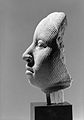 A terra-cotta head sculpture (1100-1500) of the Yoruba, showing extraordinary naturalism. This head represents the oni or king of Ife. (from Culture of Africa)
 -
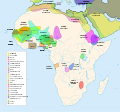 Major pre–colonial states in Africa, (excluding East African states such as Ajuran, Adal, Buganda, Rwanda, Nkore, Kilwa, Imerina, and Iboina, and southern African ones such as Mapungubwe, Rozvi, Maravi, Mutapa, Uukwanyama, Mthethwa, Mthwakazi, and Zulu) (from History of Africa)
 -
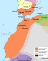 The Almoravid empire in the 12th century. (from History of Africa)
 -

-
 Ruby, Egyptian singer performing (from Culture of Africa)
 -
 Sudan basket-tray, tabar of weaved natural plant fiber, in different colors (from Culture of Africa)
 -
 Kenyan boys and girls performing a traditional folklore dance (from Culture of Africa)
 -
 Potjiekos is a traditional Afrikaner stew made with meat and vegetables and cooked over coals in cast-iron pots. (from Culture of Africa)
 -

-
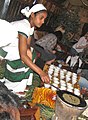 An Ethiopian woman preparing Ethiopian coffee at a traditional ceremony. She roasts, crushes, and brews the coffee on the spot. (from Culture of Africa)
 -

-
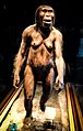 Reconstruction of "Lucy" (from History of Africa)
 -

-
 Evolution of the Fatimid Caliphate (from History of Africa)
 -
 The Ghana Empire at its greatest extent (from History of Africa)
 -
 Map of ancient Egypt, showing major cities and sites of the Dynastic period (c. 3150 BC to 30 BC) (from History of Africa)
 -

-
 Areas controlled by European powers in 1939. British (red) and Belgian (marroon) colonies fought with the Allies. Italian (light green) with the Axis. French colonies (dark blue) fought alongside the Allies until the Fall of France in June 1940. Vichy was in control until the Free French prevailed in late 1942. Portuguese (dark green) and Spanish (yellow) colonies remained neutral. (from History of Africa)
 -
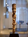
 Nok sculpture (from History of Africa)
 -
 A Yombe sculpture (Louvre, Paris) (from Culture of Africa)
 -

-
 9th-century bronze staff head in form of a coiled snake, Igbo-Ukwu, Nigeria (from History of Africa)
 -
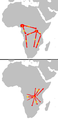
1 = 2000–1500 BC origin
2 = c. 1500 BC first dispersal
2.a = Eastern Bantu
2.b = Western Bantu
3 = 1000–500 BC Urewe nucleus of Eastern Bantu
4–7 = southward advance
9 = 500–1 BC Congo nucleus
10 = AD 1–1000 last phase (from History of Africa) -

-
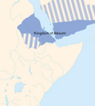 The Kingdom of Aksum in the 6th century AD. (from History of Africa)
 -

-
 Traditional male dancers from Northern Nigeria (from Culture of Africa)
 -
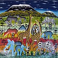 Tingatinga is one of the most widely represented forms of paintings in Tanzania, Kenya and neighbouring countries (from Culture of Africa)
 -
 Ancient Kano City Walls, Nigeria (from Culture of Africa)
 -
 Pre-Neolithic and Neolithic migration events in Africa. (from History of Africa)
 -

-
 The Great Pyramids of Giza, Egypt (from Culture of Africa)
 -
 Gateway to the Castle of Good Hope in South Africa (from Culture of Africa)


.jpg)


_5.png)


.svg)


.jpg)


Africa topics
More did you know –

- ...that the 1459 Fra Mauro map (pictured) reports that "a junk from India" rounded the Cape of Good Hope in 1420, around 70 years before the navigations of Vasco da Gama?
- ...that the 1998 Sudan famine was caused by human rights abuses in the midst of the Second Sudanese Civil War?
- ...that a smokie is a West African delicacy made by blowtorching the carcass of a sheep or goat without removing its fleece?
- ...that Anne-Marie Nzié, a Cameroonian bikutsi singer, dedicated the song Liberté to President Paul Biya and his party, the Cameroon People's Democratic Movement?
Related portals
Major Religions in Africa
North Africa
West Africa
Central Africa
East Africa
Southern Africa
Associated Wikimedia
The following Wikimedia Foundation sister projects provide more on this subject:
-
 Commons
Free media repository -
 Wikibooks
Free textbooks and manuals -
 Wikidata
Free knowledge base -
 Wikinews
Free-content news -
 Wikiquote
Collection of quotations -
 Wikisource
Free-content library -
 Wikispecies
Directory of species -
 Wikiversity
Free learning tools -
 Wikivoyage
Free travel guide -
 Wiktionary
Dictionary and thesaurus
More portals


© MMXXIII Rich X Search. We shall prevail. All rights reserved. Rich X Search