Back Портал:Географие ADY Portaal:Geografie Afrikaans Portal:Geografi ALS በር:መልክዐ ምድር Amharic بوابة:جغرافيا Arabic ܬܪܥܐ:ܓܘܓܪܦܝܐ ARC قيسارية:جغرافيا ARY بوابة:جغرافيا ARZ Portal:Coğrafiya Azerbaijani پوْرتال:جوغرافیا AZB
The Geography Portal

Geography (from Ancient Greek γεωγραφία geōgraphía; combining gê 'Earth' and gráphō 'write') is the study of the lands, features, inhabitants, and phenomena of Earth. Geography is an all-encompassing discipline that seeks an understanding of Earth and its human and natural complexities—not merely where objects are, but also how they have changed and come to be. While geography is specific to Earth, many concepts can be applied more broadly to other celestial bodies in the field of planetary science. Geography has been called "a bridge between natural science and social science disciplines."
Origins of many of the concepts in geography can be traced to Greek Eratosthenes of Cyrene, who may have coined the term "geographia" (c. 276 BC – c. 195/194 BC). The first recorded use of the word γεωγραφία was as the title of a book by Greek scholar Claudius Ptolemy (100 – 170 AD). This work created the so-called "Ptolemaic tradition" of geography, which included "Ptolemaic cartographic theory." However, the concepts of geography (such as cartography) date back to the earliest attempts to understand the world spatially, with the earliest example of an attempted world map dating to the 9th century BCE in ancient Babylon. The history of geography as a discipline spans cultures and millennia, being independently developed by multiple groups, and cross-pollinated by trade between these groups. The core concepts of geography consistent between all approaches are a focus on space, place, time, and scale.
Today, geography is an extremely broad discipline with multiple approaches and modalities. There have been multiple attempts to organize the discipline, including the four traditions of geography, and into branches. Techniques employed can generally be broken down into quantitative and qualitative approaches, with many studies taking mixed-methods approaches. Common techniques include cartography, remote sensing, interviews, and surveying. (Full article...)
 Featured article -
-

Everglades National Park is an American national park that protects the southern twenty percent of the original Everglades in Florida. The park is the largest tropical wilderness in the United States and the largest wilderness of any kind east of the Mississippi River. An average of one million people visit the park each year. Everglades is the third-largest national park in the contiguous United States after Death Valley and Yellowstone. UNESCO declared the Everglades & Dry Tortugas Biosphere Reserve in 1976 and listed the park as a World Heritage Site in 1979, and the Ramsar Convention included the park on its list of Wetlands of International Importance in 1987. Everglades is one of only three locations in the world to appear on all three lists.
Most national parks preserve unique geographic features; Everglades National Park was the first created to protect a fragile ecosystem. The Everglades are a network of wetlands and forests fed by a river flowing 0.25 miles (0.40 km) per day out of Lake Okeechobee, southwest into Florida Bay. The park is the most significant breeding ground for tropical wading birds in North America and contains the largest mangrove ecosystem in the Western Hemisphere. Thirty-six threatened or protected species inhabit the park, including the Florida panther, the American crocodile, and the West Indian manatee, along with 350 species of birds, 300 species of fresh and saltwater fish, 40 species of mammals, and 50 species of reptiles. The majority of South Florida's fresh water, which is stored in the Biscayne Aquifer, is recharged in the park. (Full article...) -

Ice core sample taken from drill
An ice core is a core sample that is typically removed from an ice sheet or a high mountain glacier. Since the ice forms from the incremental buildup of annual layers of snow, lower layers are older than upper ones, and an ice core contains ice formed over a range of years. Cores are drilled with hand augers (for shallow holes) or powered drills; they can reach depths of over two miles (3.2 km), and contain ice up to 800,000 years old.
The physical properties of the ice and of material trapped in it can be used to reconstruct the climate over the age range of the core. The proportions of different oxygen and hydrogen isotopes provide information about ancient temperatures, and the air trapped in tiny bubbles can be analysed to determine the level of atmospheric gases such as carbon dioxide. Since heat flow in a large ice sheet is very slow, the borehole temperature is another indicator of temperature in the past. These data can be combined to find the climate model that best fits all the available data. (Full article...) -
In June 1941, Serbs in eastern Herzegovina rebelled against the authorities of the Independent State of Croatia (Croatian: Nezavisna Država Hrvatska, NDH), an Axis puppet state established during World War II on the territory of the defeated and occupied Kingdom of Yugoslavia. As the NDH imposed its authority, members of the fascist Ustaše ruling party began a genocidal campaign against Serbs throughout the country. In eastern Herzegovina, the Ustaše perpetrated a series of massacres and attacks against the majority Serb population commencing in the first week of June. Between 3 and 22 June 1941, spontaneous clashes occurred between NDH authorities and groups of Serbs in the region.
The German invasion of the Soviet Union began on 22 June. Over the next two days, the sporadic revolts by Serbs against the NDH in eastern Herzegovina erupted into mass rebellion, triggered by Ustaše persecution, Serb solidarity with the Russian people, hatred and fear of the NDH authorities, and other factors. Serb rebels, under the leadership of both local Serbs and Montenegrins, attacked police, gendarmerie, Ustaše and Croatian Home Guard forces in the region. In the first few days, the rebels captured gendarmerie posts in several villages, set up roadblocks on the major roads and ambushed several military vehicles. On the night of 26 June, the rebels mounted a sustained attack on the town of Nevesinje in an attempt to capture it, but the garrison held out until the morning of 28 June when NDH troops broke through the rebel roadblocks. (Full article...) -
Taapaca is a Holocene volcanic complex in northern Chile's Arica y Parinacota Region. Located in the Chilean Andes, it is part of the Central Volcanic Zone of the Andean Volcanic Belt, one of four distinct volcanic chains in South America. The town of Putre lies at the southwestern foot of the volcano.
Like other volcanoes of the Central Volcanic Zone, Taapaca formed from the subduction of the Nazca Plate beneath the South America Plate. It lies on the western margin of the Altiplano high plateau, on top of older volcanic and sedimentary units. Taapaca has mainly erupted dacite, in the form of numerous lava domes, although an andesitic stratovolcano is also present. (Full article...) -
Aliso Creek is a 19.8-mile (31.9 km)-long, mostly urban stream in south Orange County, California. Originating in the Cleveland National Forest in the Santa Ana Mountains, it flows generally southwest and empties into the Pacific Ocean at Laguna Beach. The creek's watershed drains 34.9 square miles (90 km2), and it is joined by seven main tributaries. As of 2018, the watershed had a population of 144,000 divided among seven incorporated cities.
Aliso Creek flows over highly erosive marine sedimentary rock of late Eocene to Pliocene age. What would become the Aliso Creek watershed originally lay at the bottom of the Pacific Ocean, before being uplifted as recently as 10 million years ago. About 1.2 million years ago, the San Joaquin Hills began to uplift in the path of Aliso Creek. Occasionally swollen by wetter climates during glacial periods, the creek carved the deep water gap known today as Aliso Canyon, the main feature of Aliso and Wood Canyons Wilderness Park. (Full article...) -
Little Butte Creek is a 17-mile-long (27 km) tributary of the Rogue River in the U.S. state of Oregon. Its drainage basin consists of approximately 354 square miles (917 km2) of Jackson County and another 19 square miles (49 km2) of Klamath County. Its two forks, the North Fork and the South Fork, both begin high in the Cascade Range near Mount McLoughlin and Brown Mountain. They both flow generally west until they meet near Lake Creek. The main stem continues west, flowing through the communities of Brownsboro, Eagle Point, and White City, before finally emptying into the Rogue River about 3 miles (5 km) southwest of Eagle Point.
Little Butte Creek's watershed was originally settled by the Takelma, and possibly the Shasta tribes of Native Americans. In the Rogue River Wars of the 1850s, most of the Native Americans were either killed or forced onto Indian reservations. Early settlers named Little Butte Creek and nearby Big Butte Creek after their proximity to Mount McLoughlin, which was known as Snowy Butte. In the late 19th century, the watershed was primarily used for agriculture and lumber production. The city of Eagle Point was incorporated in 1911, and remains the only incorporated town within the watershed's boundaries. (Full article...) -
Arlington is a city in northern Snohomish County, Washington, United States, part of the Seattle metropolitan area. The city lies on the Stillaguamish River in the western foothills of the Cascade Range, adjacent to the city of Marysville. It is approximately 10 miles (16 km) north of Everett, the county seat, and 40 miles (64 km) north of Seattle, the state's largest city. As of the 2020 U.S. census, Arlington had a population of 19,868; its estimated population is 20,075 as of 2021.
The city lies in the traditional territory of the Stillaguamish people, an indigenous Coast Salish group. Arlington was established in the 1880s by settlers and the area was platted as two towns, Arlington and Haller City. Haller City was absorbed by the larger Arlington, which was incorporated as a city in 1903. During the Great Depression of the 1930s, the Arlington area was the site of major projects undertaken for employment under the direction of federal relief agencies, including construction of a municipal airport that would serve as a naval air station during World War II. Arlington began suburbanizing in the 1980s, growing by more than 450 percent by 2000 and annexing the unincorporated area of Smokey Point to the southwest. (Full article...) -
Ficus obliqua, commonly known as the small-leaved fig, is a tree in the family Moraceae, native to eastern Australia, New Guinea, eastern Indonesia to Sulawesi and islands in the southwestern Pacific Ocean. Previously known for many years as Ficus eugenioides, it is a banyan of the genus Ficus, which contains around 750 species worldwide in warm climates, including the edible fig (Ficus carica). Beginning life as a seedling, which grows on other plants (epiphyte) or on rocks (lithophyte), F. obliqua can grow to 60 m (200 ft) high and nearly as wide with a pale grey buttressed trunk, and glossy green leaves.
The small round yellow fruit ripen and turn red at any time of year, although ripening peaks in autumn and winter (April to July). Known as a syconium, the fruit is an inverted inflorescence with the flowers lining an internal cavity. Ficus obliqua is pollinated by two species of fig wasp—Pleistodontes greenwoodi and P. xanthocephalus. Many species of bird, including pigeons, parrots and various passerines, eat the fruit. The range is along the east coast from Queensland, through New South Wales in rainforest, savanna woodland, sclerophyll forest and gallery forest. It is used as a shade tree in parks and public spaces, and is well-suited for use as an indoor plant or in bonsai. All parts of the tree have been used in traditional medicine in Fiji. (Full article...) -

Macedonia (/ˌmæsɪˈdoʊniə/ MASS-ih-DOH-nee-ə; Greek: Μακεδονία), also called Macedon (/ˈmæsɪdɒn/ MASS-ih-don), was an ancient kingdom on the periphery of Archaic and Classical Greece, which later became the dominant state of Hellenistic Greece. The kingdom was founded and initially ruled by the royal Argead dynasty, which was followed by the Antipatrid and Antigonid dynasties. Home to the ancient Macedonians, the earliest kingdom was centered on the northeastern part of the Greek peninsula, and bordered by Epirus to the southwest, Illyria to the northwest, Paeonia to the north, Thrace to the east and Thessaly to the south.
Before the 4th century BC, Macedonia was a small kingdom outside of the area dominated by the great city-states of Athens, Sparta and Thebes, and briefly subordinate to Achaemenid Persia. During the reign of the Argead king Philip II (359–336 BC), Macedonia subdued mainland Greece and the Thracian Odrysian kingdom through conquest and diplomacy. With a reformed army containing phalanxes wielding the sarissa pike, Philip II defeated the old powers of Athens and Thebes in the Battle of Chaeronea in 338 BC. Philip II's son Alexander the Great, leading a federation of Greek states, accomplished his father's objective of commanding the whole of Greece when he destroyed Thebes after the city revolted. During Alexander's subsequent campaign of conquest, he overthrew the Achaemenid Empire and conquered territory that stretched as far as the Indus River. For a brief period, his Macedonian Empire was the most powerful in the world – the definitive Hellenistic state, inaugurating the transition to a new period of Ancient Greek civilization. Greek arts and literature flourished in the new conquered lands and advances in philosophy, engineering, and science spread across the empire and beyond. Of particular importance were the contributions of Aristotle, tutor to Alexander, whose writings became a keystone of Western philosophy. (Full article...) -

The Iğdır Genocide Memorial and Museum promotes the false view that Armenians committed genocide against Turks, rather than vice versa.
Armenian genocide denial is the claim that the Ottoman Empire and its ruling party, the Committee of Union and Progress (CUP), did not commit genocide against its Armenian citizens during World War I—a crime documented in a large body of evidence and affirmed by the vast majority of scholars. The perpetrators denied the genocide as they carried it out, claiming that Armenians in the Ottoman Empire were resettled for military reasons, not exterminated. In the genocide's aftermath, incriminating documents were systematically destroyed, and denial has been the policy of every government of the Republic of Turkey, , and later adopted by the Republic of Azerbaijan, as of 1991.
Borrowing arguments used by the CUP to justify its actions, denial of the Armenian genocide rests on the assumption that the "relocation" of Armenians was a legitimate state action in response to a real or perceived Armenian uprising that threatened the existence of the empire during wartime. Deniers assert the CUP intended to resettle Armenians rather than kill them. They claim the death toll is exaggerated or attribute the deaths to other factors, such as a purported civil war, disease, bad weather, rogue local officials, or bands of Kurds and outlaws. Historian Ronald Grigor Suny summarizes the main argument as "there was no genocide, and the Armenians were to blame for it". (Full article...) -

The Socialist Soviet Republic of Abkhazia (SSR Abkhazia) was a short-lived republic within the Caucasus region of the Soviet Union that covered the territory of Abkhazia, and existed from 31 March 1921 to 19 February 1931. Formed in the aftermath of the Red Army invasion of Georgia in 1921, it was independent until 16 December 1921 when it agreed to a treaty that united it with the Georgian Soviet Socialist Republic (Georgian SSR). The SSR Abkhazia was similar to an autonomous Soviet republic, though it retained nominal independence from Georgia and was given certain features only full union republics had, like its own military units. Through its status as a "treaty republic" with Georgia, Abkhazia joined the Transcaucasian Soviet Federative Socialist Republic, which united Armenian, Azerbaijani, and Georgian SSRs into one federal unit when the latter was formed in 1922. The SSR Abkhazia was abolished in 1931 and replaced with the Abkhaz Autonomous Soviet Socialist Republic within the Georgian SSR.
During its existence, the SSR Abkhazia was led by Nestor Lakoba, who served officially as the Chairman of the Council of People's Commissars but controlled the republic to such an extent that it was jokingly referred to as "Lakobistan". Due to Lakoba's close relationship with Soviet leader Joseph Stalin, collectivisation was delayed until after Abkhazia was incorporated into Georgia. Abkhazia remained a major tobacco producer in this era, growing over half of the USSR's supply. It also produced other agricultural produce, including tea, wine, and citrus fruits, leading to Abkhazia being one of the wealthiest regions in the Soviet Union. Its sub-tropical climate also made it a prime holiday destination, with Stalin and other Soviet leaders owning dachas (holiday homes) in the region and spending considerable time there. (Full article...) -
Powder House Island (also known as Dynamite Island) is an artificial island on the lower Detroit River in southeast Michigan, directly adjacent to the Canada–United States border. It was constructed in the late 1880s by the Dunbar & Sullivan Company to store explosives during their dredging of the Livingstone Channel, with the purpose of circumventing an 1880 court order forbidding the company to store explosives on nearby Fox Island.
Powder House Island was the location of dynamite storage sheds, as well as a dynamite factory and several ice houses. During this time, it was the site of a series of accidents, including fires in 1895 and 1919 (which both burned the island "to the water's edge"). Twenty short tons (18,000 kg) of the island's dynamite exploded in 1906 after two men "had been shooting with a revolver" near it; while there were no deaths (and only minor injuries to the two men), windows were shattered 3 mi (4.8 km) away and the explosion was clearly audible from 85 mi (137 km) away. (Full article...) -
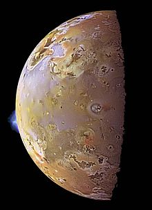
Io, with two plumes erupting from its surface
Volcanism on Io, a moon of Jupiter, is represented by the presence of volcanoes, volcanic pits and lava flows on the surface. Io's volcanic activity was discovered in 1979 by Linda Morabito, an imaging scientist working on Voyager 1. Observations of Io by passing spacecraft and Earth-based astronomers have revealed more than 150 active volcanoes. , up to 400 such volcanoes are predicted to exist based on these observations.[outdated statistic] Io's volcanism makes the satellite one of only four known currently volcanically or cryovolcanically active worlds in the Solar System (the others being Earth, Saturn's moon Enceladus, and Neptune's moon Triton.)
First predicted shortly before the Voyager 1 flyby, the heat source for Io's volcanism comes from tidal heating produced by its forced orbital eccentricity. This differs from Earth's internal heating, which is derived primarily from radioactive isotope decay and primordial heat of accretion. Io's eccentric orbit leads to a slight difference in Jupiter's gravitational pull on the satellite between its closest and farthest points on its orbit, causing a varying tidal bulge. This variation in the shape of Io causes frictional heating in its interior. Without this tidal heating, Io might have been similar to the Moon, a world of similar size and mass, geologically dead and covered with numerous impact craters. (Full article...) -
The Boring Lava Field (also known as the Boring Volcanic Field) is a Plio-Pleistocene volcanic field with cinder cones, small shield volcanoes, and lava flows in the northern Willamette Valley of the U.S. state of Oregon and adjacent southwest Washington. The field got its name from the town of Boring, Oregon, located 12 miles (20 km) southeast of downtown Portland. Boring lies southeast of the densest cluster of lava vents. The zone became volcanically active about 2.7 million years ago, with long periods of eruptive activity interspersed with quiescence. Its last eruptions took place about 57,000 years ago at the Beacon Rock cinder cone volcano; the individual volcanic vents of the field are considered extinct, but the field itself is not.
The Boring Lava Field covers an area of about 1,500 square miles (4,000 km2), and has a total volume of 2.4 cubic miles (10 km3). This region sustains diverse flora and fauna within its habitat areas, which are subject to Portland's moderate climate with variable temperatures and mild precipitation. The highest elevation of the field is at Larch Mountain, which reaches a height of 4,055 feet (1,236 m). (Full article...) -
Ham Wall is an English wetland National Nature Reserve (NNR) 4 kilometres (2.5 mi) west of Glastonbury on the Somerset Levels. It is managed by the Royal Society for the Protection of Birds (RSPB). Since the last Ice Age, decomposing plants in the marshes of the Brue valley in Somerset have accumulated as deep layers of peat that were commercially exploited on a large scale in the twentieth century. Consumer demand eventually declined, and in 1994 the landowners, Fisons, gave their old workings to what is now Natural England, who passed the management of the 260 hectares (640 acres) Ham Wall section to the RSPB.
The Ham Wall reserve was constructed originally to provide reed bed habitat for the Eurasian bittern, which at the time was at a very low population level in the UK. The site is divided into several sections with independently controllable water levels, and machinery and cattle are used to maintain the quality of the reed beds. There are important breeding populations of wetland birds including the rare little bittern and great white egret, and the area hosts several other uncommon animals and plants. The RSPB works with other organisations as part of the Avalon Marshes Partnership to coordinate conservation issues across the Somerset Levels. (Full article...)

.jpg)


.svg)


 Vital article
.svg)
Other vital articles
|
|---|
Related portals
Get involved
 |
Here are some tasks awaiting attention:
|
Selected pictures
-
 Photo credit: Joaquim Alves GasparIllustration of the Ptolemaic geocentric model of the Universe (the theory that the Earth is the center of the universe) by Portuguese cosmographer and cartographer Bartolomeu Velho. Taken from his treatise Cosmographia, made in Paris, 1568. Notice the distances of the bodies to the centre of the Earth (left) and the times of revolution, in years (right).
 -
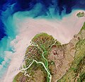 Photograph credit: European Space Agency / Sentinel-2The Yukon Delta is a river delta formed by the Yukon River as it drains into the Bering Sea. It is part of the larger Yukon–Kuskokwim Delta, which includes the delta of the Kuskokwim River. The Yukon River rises in British Columbia, Canada, and flows through Yukon before entering the U.S. state of Alaska. This August 2017 satellite image of the Yukon Delta shows how the river branches into numerous distributary channels that meander through the low-lying terrain on their way to the sea. The sandy colour of these channels and the coastal water is indicative of the marine sediment the river carries to the sea at this time of year.
 -
 Map: Strebe, using GeocartThe Winkel tripel projection is a modified azimuthal map projection proposed by Oswald Winkel in 1921. The arithmetic mean of the equirectangular projection and the Aitoff projection, it was intended as a compromise between minimizing three kinds of distortion: area, direction and distance.
The imagery used for the map is derived from NASA's Blue Marble summer months composite, with oceans lightened to enhance legibility and contrast. -
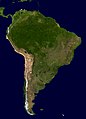 A composite relief satellite image of South America, the fourth-largest continent. South America occupies the southern portion of the landmass in the Western Hemisphere. The continent is generally delimited on the northwest by the Darién watershed along the Colombia–Panama border. Almost all of mainland South America sits on the South American Plate, as do nearby outlying islands.
 -
 Map: Jorge de AguiarA portolan chart from 1492, the oldest known signed and dated chart of Portuguese origin. Cartography technologies greatly advanced during the Age of Discovery. Iberian mapmakers in particular focused on practical charts to use as navigational aids. Unlike Spanish maps which were regarded as state secrets, Portuguese ones were used by other countries, and Portuguese cartographers drew upon the skill and knowledge of other cultures as well.
 -
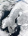 A satellite image of the Scandinavian Peninsula in winter. The peninsula, approximately 1,850 kilometers (1,150 miles) long with a width varying between approximately 370–805 km (230–500 mi), making it the largest in Europe, is located in the northern part of the continent and consists of Norway, Sweden and part of Finland. Much of the population is concentrated in the southern part of the peninsula; Stockholm and Gothenburg, both in Sweden, and Oslo in Norway are the largest cities.
 -
 Image: Chris RywaltAn animation showing the unfolding of a Dymaxion map, a projection of a world map onto the surface of a polyhedron (in this case, an icosahedron) and then flattened to form a two-dimensional map which retains most of the relative proportional integrity of the globe map. This type of map was invented by Buckminster Fuller and is one of several of his inventions to use the name Dymaxion.
 -
 Map: William C. Woodbridge; Restoration: Jujutacular and Lise BroerAn isothermal map of the world, based on the research of Alexander von Humboldt, a German naturalist whose work laid the foundation for the sciences of physical geography and meteorology, among other things. By delineating "isothermal lines", he simultaneously suggested the idea and devised the means of comparing the climatic conditions of various countries.
 -
 Map: Strebe, using GeocartThe equirectangular projection is a simple map projection attributed to Marinus of Tyre, who Ptolemy claims invented the projection about AD 100. The projection maps meridians to vertical straight lines of constant spacing, and circles of latitude to horizontal straight lines of constant spacing. The projection is neither equal area nor conformal. Because of the distortions introduced by this projection, it has few applications beyond base imagery to be reprojected to some more useful projection.
 -
 Map: Strebe, using GeocartThe Gall–Peters projection, named after James Gall and Arno Peters, is a specialization of a configurable equal-area map projection known as the cylindrical equal-area projection. It achieved considerable notoriety in the late 20th century as the centerpiece of a controversy surrounding the political implications of map design; Peters promoted it as a more faithful representation than the Mercator projection, which inflates the sizes of regions farther from the equator and thus makes the (mostly technologically underdeveloped) equatorial countries appear smaller and therefore, according to Peters, less significant.
 -
 Map: Strebe, using GeocartThe Lambert conformal conic projection is a conic map projection used for aeronautical charts, portions of the State Plane Coordinate System, and many national and regional mapping systems. It is one of seven projections introduced by Johann Heinrich Lambert in 1772. Conceptually, the projection seats a cone over the sphere of the Earth and projects the surface conformally onto the cone. The cone is unrolled, and the parallel that was touching the sphere is assigned unit scale. By scaling the resulting map, two parallels can be assigned unit scale, with scale decreasing between them and increasing outside them. Unlike other conic projections, no true secant form of this projection exists.
 -
 The geography of Australia, the world's smallest continent, encompasses a wide variety of biogeographic regions. By surface area, it is the sixth-largest country in the world, but as can be seen in this composite satellite image, much of the interior is arid desert. The vast majority of the human population is concentrated along the eastern and southeastern coasts, and it is the fiftieth most populous nation.
 -
 Map: Strebe, using GeocartThe sinusoidal projection is a pseudocylindrical equal-area map projection. Used as early as the 16th century, this projection shows distances accurately along the central meridian and the equator; areas furthest from these lines are the most distorted.
 -
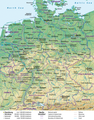 Map credit: Lencer and NordNordWestA general map, showing the geography of Germany, the seventh largest country in Europe and the second most populous. Located in Central Europe, Germany is second only to Russia in the number of borders it shares with other European countries (9).
 -
 Map: Strebe, using GeocartThe Robinson projection is a map projection of a world map which shows the entire world at once. It was devised by Arthur H. Robinson in 1963 in response to an appeal from the Rand McNally company for a good compromise to the problem of readily showing the whole globe as a flat image. The company has used the projection since that time, and the National Geographic Society used the Robinson from 1988 to 1998.


Featured biography

Daniel Boone (November 2 [O.S. October 22], 1734 – September 26, 1820) was an American pioneer and frontiersman whose exploits made him one of the first folk heroes of the United States. He became famous for his exploration and settlement of Kentucky, which was then beyond the western borders of the Thirteen Colonies. In 1775, Boone blazed the Wilderness Road through the Cumberland Gap and into Kentucky, in the face of resistance from American Indians. He founded Boonesborough, one of the first English-speaking settlements west of the Appalachian Mountains. By the end of the 18th century, more than 200,000 people had entered Kentucky by following the route marked by Boone.
Boone served as a militia officer during the Revolutionary War (1775–1783), which was fought in Kentucky primarily between American settlers and British-allied Indians. Boone was taken in by Shawnees in 1778 and adopted into the tribe, but he resigned and continued to help protect the Kentucky settlements. He also left due to the Shawnee Indians torturing and killing one of his sons. He was elected to the first of his three terms in the Virginia General Assembly during the war and fought in the Battle of Blue Licks in 1782, one of the last battles of the American Revolution. He worked as a surveyor and merchant after the war, but went deep into debt as a Kentucky land speculator. He resettled in Missouri in 1799, where he spent most of the last two decades of his life, frustrated with legal problems resulting from his land claims. (Full article...)More featured biographies
|
|---|
Did you know
- ... that glaciation in Wisconsin 17 thousand years ago helped create its unique geography?
- ... that Johann Reinhold Forster's 1778 book Observations Made During a Voyage Round the World has been described as "the beginning of modern geography"?
Places around you
Top 10 WikiProject Geography Popular articles of the month
-
Generation Z (often shortened to Gen Z), also known as Zoomers, is the demographic cohort succeeding Millennials and preceding Generation Alpha. Researchers and popular media use the mid-to-late 1990s as starting birth years and the early 2010s as ending birth years. Most members of Generation Z are the children of Generation X or older Millennials. (Full article...)
-

A map of the United States showing its 50 states, federal district and five inhabited territories. Alaska, Hawaii, and the territories are shown at different scales, and the Aleutian Islands and the uninhabited northwestern Hawaiian Islands are omitted from the map.
The United States of America is a federal republic consisting of 50 states, a federal district (Washington, D.C., the capital city of the United States), five major territories, and various minor islands. Both the states and the United States as a whole are each sovereign jurisdictions. The Tenth Amendment to the United States Constitution allows states to exercise all powers of government not delegated to the federal government. Each state has its own constitution and government, and all states and their residents are represented in the federal Congress, a bicameral legislature consisting of the Senate and the House of Representatives. Each state is represented by two senators, while representatives are distributed among the states in proportion to the most recent constitutionally mandated decennial census. Additionally, each state is entitled to select a number of electors to vote in the Electoral College, the body that elects the president of the United States, equal to the total of representatives and senators in Congress from that state. The federal district does not have representatives in the Senate, but has a non-voting delegate in the House, and it is also entitled to electors in the Electoral College. Congress can admit more states, but it cannot create a new state from territory of an existing state or merge two or more states into one without the consent of all states involved, and each new state is admitted on an equal footing with the existing states. (Full article...) -
Earth is the third planet from the Sun and the only astronomical object known to harbor life. This is enabled by Earth being an ocean world, the only one in the Solar System sustaining liquid surface water. Almost all of Earth's water is contained in its global ocean, covering 70.8% of Earth's crust. The remaining 29.2% of Earth's crust is land, most of which is located in the form of continental landmasses within Earth's land hemisphere. Most of Earth's land is somewhat humid and covered by vegetation, while large sheets of ice at Earth's polar deserts retain more water than Earth's groundwater, lakes, rivers and atmospheric water combined. Earth's crust consists of slowly moving tectonic plates, which interact to produce mountain ranges, volcanoes, and earthquakes. Earth has a liquid outer core that generates a magnetosphere capable of deflecting most of the destructive solar winds and cosmic radiation. (Full article...) -
Generation X (often shortened to Gen X) is the demographic cohort following the Baby Boomers and preceding Millennials. Researchers and popular media often use the mid-1960s as its starting birth years and the late 1970s as its ending birth years, with the generation being generally defined as people born from 1965 to 1980. By this definition and U.S. Census data, there are 65.2 million Gen Xers in the United States as of 2019. Most of Generation X are the children of the Silent Generation and early Baby Boomers; Xers are also often the parents of Millennials and Generation Z. (Full article...)
-

England is a country that is part of the United Kingdom. It is located on the island of Great Britain, of which it covers approximately 62%, and over 100 smaller adjacent islands. It has land borders with Scotland to the north and Wales to the west, and is otherwise surrounded by the North Sea to the east, the English Channel to the south, the Celtic Sea to the south-west, and the Irish Sea to the west. Continental Europe lies to the south-east, and Ireland to the west. At the 2021 census, the population was 56,490,048. London is both the largest city and the capital. (Full article...) -
London (/ˈlʌndən/ LUN-dən) is the capital and largest city of both England and the United Kingdom, with a population of 8,866,180 in 2022. The wider metropolitan area is the largest in Western Europe, with a population of 14.9 million. London stands on the River Thames in southeast England, at the head of a 50-mile (80 km) estuary down to the North Sea, and has been a major settlement for nearly 2,000 years. Its ancient core and financial centre, the City of London, was founded by the Romans as Londinium and has retained its medieval boundaries. The City of Westminster, to the west of the City of London, has been the centuries-long host of the national government and parliament. London grew rapidly in the 19th century, becoming the world's largest city at the time. Since the 19th century, the name "London" has referred to the metropolis around the City of London, historically split between the counties of Middlesex, Essex, Surrey, Kent, and Hertfordshire, which since 1965 has largely comprised the administrative area of Greater London, governed by 33 local authorities and the Greater London Authority. (Full article...) -

Cartogram of the world's population in 2018; each square represents 500,000 people.[needs update?]
This is a list of countries and dependencies by population. It includes sovereign states, inhabited dependent territories and, in some cases, constituent countries of sovereign states, with inclusion within the list being primarily based on the ISO standard ISO 3166-1. For instance, the United Kingdom is considered a single entity, while the constituent countries of the Kingdom of the Netherlands are considered separately. In addition, this list includes certain states with limited recognition not found in ISO 3166-1. Also given in a percentage is each country's population compared with the world population, which the United Nations estimates at 8.12 billion as of 2024. (Full article...) -
Europe is a continent located entirely in the Northern Hemisphere and mostly in the Eastern Hemisphere. It is bordered by the Arctic Ocean to the north, the Atlantic Ocean to the west, the Mediterranean Sea to the south, and Asia to the east. Europe shares the landmass of Eurasia with Asia, and of Afro-Eurasia with both Asia and Africa. Europe is commonly considered to be separated from Asia by the watershed of the Ural Mountains, the Ural River, the Caspian Sea, the Greater Caucasus, the Black Sea, and the waterway of the Bosporus Strait. (Full article...)
-
Millennials, also known as Generation Y or Gen Y, are the demographic cohort following Generation X and preceding Generation Z. Researchers and popular media use the early 1980s as starting birth years and the mid-1990s to early 2000s as ending birth years, with the generation typically being defined as people born from 1981 to 1996. Most Millennials are the children of Baby Boomers and older Generation X. In turn Millennials are often the parents of Generation Alpha. (Full article...)
-

Hong Kong is a special administrative region of the People's Republic of China. With 7.4 million residents of various nationalities in a 1,104-square-kilometre (426 sq mi) territory, Hong Kong is one of the most densely populated territories in the world. (Full article...)

.jpg)

.jpeg)


Featured pictures


Main articles
 Categories
Associated Wikimedia
The following Wikimedia Foundation sister projects provide more on this subject:
-
 Commons
Free media repository -
 Wikibooks
Free textbooks and manuals -
 Wikidata
Free knowledge base -
 Wikinews
Free-content news -
 Wikiquote
Collection of quotations -
 Wikisource
Free-content library -
 Wikiversity
Free learning tools -
 Wikivoyage
Free travel guide -
 Wiktionary
Dictionary and thesaurus


© MMXXIII Rich X Search. We shall prevail. All rights reserved. Rich X Search