Back Πύλη:Βιρτζίνια Greek Portal:Virginia Spanish Portail:Virginie French Portal:Virgínia Portuguese
The Virginia Portal  Virginia, officially the Commonwealth of Virginia, is a state in the Southeastern and Mid-Atlantic regions of the United States between the Atlantic Coast and the Appalachian Mountains. The state's capital is Richmond and its most populous city is Virginia Beach, though its most populous subdivision is Fairfax County, part of Northern Virginia, where slightly over a third of Virginia's population of 8.7 million live. Eastern Virginia is part of the Atlantic Plain, and the Middle Peninsula forms the mouth of the Chesapeake Bay. Central Virginia lies predominantly in the Piedmont, the foothill region of the Blue Ridge Mountains, which cross the western and southwestern parts of the state. The fertile Shenandoah Valley fosters the state's most productive agricultural counties, while the economy in Northern Virginia is driven by technology companies and U.S. federal government agencies, including the U.S. Department of Defense and Central Intelligence Agency. Hampton Roads is also the site of the region's main seaport and Naval Station Norfolk, the world's largest naval base. (Full article...) Selected article
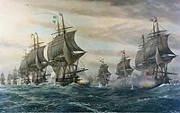
The Battle of the Chesapeake, also known as the Battle of the Virginia Capes, was a crucial naval battle in the American War of Independence that took place near the mouth of Chesapeake Bay on 5 September 1781, between a British fleet led by Rear Admiral Sir Thomas Graves and a French fleet led by Rear Admiral François Joseph Paul, comte de Grasse.
Sailing south from New York with 19 ships of the line, Graves arrived at the mouth of the Chesapeake early on 5 September to see de Grasse's fleet of 24 ships of the line at anchor in the bay. De Grasse sailed out to meet Graves. In a two-hour engagement after hours of manoeuvring, the lines of the two fleets did not completely meet nor fully engage. The battle was consequently fairly evenly matched. The battle was tactically inconclusive but strategically a major defeat for the British, since it prevented the Royal Navy from reinforcing or evacuating the blockaded forces of Lieutenant General Lord Cornwallis at Yorktown. As a result, Cornwallis surrendered his army after the Siege of Yorktown, resulting in negotiations that eventually resulted in peace and British recognition of the independent United States of America. Selected biographyGrace Sherwood (c. 1660 – c. 1740), known as the "Witch of Pungo", is the last person known to have been convicted of witchcraft in Virginia. A farmer, healer, and midwife, her neighbors accused her of transforming herself into a cat, damaging crops and causing the death of livestock. Sherwood lived in Pungo, Princess Anne County(today part of Virginia Beach). She was charged with witchcraft several times. Sherwood's first case was in 1697; she was accused of casting a spell on a bull, resulting in its death, but the matter was dismissed by the agreement of both parties. The following year she was accused of witchcraft by two neighbors; she supposedly bewitched the hogs and cotton crop of one of them. Sherwood sued for slander after each accusation but her lawsuits were unsuccessful and her husband had to pay court costs. At her eventual trial in 1706, Sherwood was accused of bewitching Elizabeth Hill, causing Hill to miscarry. The court ordered that Sherwood's guilt or innocence be determined by ducking her in water. If she sank, she was innocent; if she did not, she was guilty. Sherwood floated to the surface, and was convicted. Freed from prison by 1714, she recovered her property from Princess Anne County, after which she lived on her farm until her death in 1740 at the age of about 80. On July 10, 2006, the 300th anniversary of Sherwood's conviction, Governor Tim Kaine restored her good name, recognizing that her case was a miscarriage of justice. This month in Virginia history
Random Virginia articleA random generator will select an article about… 
(note: generator may be slow) Things you can do
Tasks
Selected image Monticello, the self-designed home of Thomas Jefferson, in Albemarle County, Virginia Did you know -
Fact sheet
State symbols:
Government
Related portalsVirginia topicsSubcategoriesSelect [+] to view subcategories
Associated WikimediaThe following Wikimedia Foundation sister projects provide more on this subject:
Discover Wikipedia using portals |
© MMXXIII Rich X Search. We shall prevail. All rights reserved. Rich X Search


