Back پاوند ريدچ (نيو يورك) ARZ Паунд-Ридж (Нью-Йорк) CE Pound Ridge CEB Pound Ridge, Efrog Newydd Welsh Pound Ridge German Pound Ridge Spanish Pound Ridge (New York) Basque Pound Ridge (New York) French Pound Ridge, New York HT Pound Ridge Italian
Pound Ridge, New York | |
|---|---|
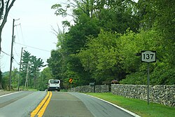
 NY State Route 137 in Pound Ridge | |
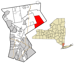
 Location of Pound Ridge, New York | |
| Coordinates: 41°12′28″N 73°34′47″W / 41.20778°N 73.57972°W | |
| Country | United States |
| State | New York |
| County | Westchester |
| Founded | 1788 |
| Government | |
| • Town Supervisor | Kevin C. Hansan[1] |
| Area | |
| • Total | 23.09 sq mi (59.80 km2) |
| • Land | 22.31 sq mi (57.78 km2) |
| • Water | 0.78 sq mi (2.02 km2) |
| Elevation | 614 ft (187 m) |
| Population | |
| • Total | 5,082 |
| • Density | 227.79/sq mi (87.95/km2) |
| Time zone | UTC−5 (Eastern (EST)) |
| • Summer (DST) | UTC−4 (EDT) |
| ZIP Code | 10576 |
| Area code | 914 |
| FIPS code | 36-59685 |
| GNIS feature ID | 0979394 |
| Website | www.townofpoundridge.com |
Pound Ridge is a town in Westchester County, New York, United States. The population was 5,082 at the 2020 census.[3] The town is located toward the eastern end of the county, bordered to the north and east by the town of Lewisboro, by Stamford, Connecticut, and New Canaan, Connecticut, to the south, Bedford, New York, and North Castle to the west.
- ^ "Supervisor's Office Home". Town of Pound Ridge. Retrieved January 25, 2018.
- ^ "2020 U.S. Gazetteer Files". United States Census Bureau. Retrieved March 8, 2024.
- ^ a b "Profile of General Population and Housing Characteristics: 2020 Demographic Profile Data (DP-1): Pound Ridge town, Westchester County, New York". United States Census Bureau. Retrieved March 8, 2024.
© MMXXIII Rich X Search. We shall prevail. All rights reserved. Rich X Search
