| Prenton | |
|---|---|
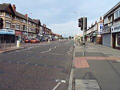
 Shops on the A552 road in Prenton | |
Location within Merseyside | |
| Population | 14,488 (2011 census Ward population) |
| OS grid reference | SJ310866 |
| • London | 178 mi (286 km)[1] SE |
| Metropolitan borough | |
| Metropolitan county | |
| Region | |
| Country | England |
| Sovereign state | United Kingdom |
| Post town | PRENTON |
| Postcode district | CH43 |
| Dialling code | 0151 |
| ISO 3166 code | GB-WRL |
| Police | Merseyside |
| Fire | Merseyside |
| Ambulance | North West |
| UK Parliament | |
Prenton is a suburb of Birkenhead, Merseyside, England. Administratively, it is also a ward of the Metropolitan Borough of Wirral. Before local government reorganisation on 1 April 1974, it was part of the County Borough of Birkenhead, within the county of Cheshire. Situated in the east of the Wirral Peninsula, the area is contiguous with Oxton to the north, Tranmere and Rock Ferry to the east and Higher Bebington to the south east. The M53 motorway marks the western boundary.
At the 2001 census, the population of Prenton was 14,429.[2] The population of the ward increased slightly to 14,488 in the 2011 census.[3]
- ^ "Coordinate Distance Calculator". boulter.com. Retrieved 6 March 2016.
- ^ "2001 Census: Prenton". Office for National Statistics. Retrieved 2 July 2007.
- ^ UK Census (2011). "Local Area Report – Prenton Ward (E05000970)". Nomis. Office for National Statistics. Retrieved 22 August 2020.
© MMXXIII Rich X Search. We shall prevail. All rights reserved. Rich X Search

