Back مقاطعة كزرتة Arabic Provincia de Caserta AST Provinz Caserta BAR Казерта (правінцыя) Byelorussian Казерта (провинция) Bulgarian Proviñs Caserta Breton Província de Caserta Catalan Caserta (lalawigan) CEB پارێزگای کەزێرتا CKB Provincie Caserta Czech
Province of Caserta | |
|---|---|
 Monti Trebulani | |
 Map highlighting the location of the province of Caserta in Italy | |
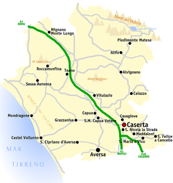
 Map of the province of Caserta | |
| Country | |
| Region | Campania |
| Capital(s) | Caserta |
| Comuni | 104 |
| Government | |
| • President | Giorgio Magliocca |
| Area | |
| • Total | 2,651.35 km2 (1,023.69 sq mi) |
| Population (1 January 2016)[1] | |
| • Total | 924,414 |
| • Density | 350/km2 (900/sq mi) |
| GDP | |
| • Total | €14.536 billion (2015) |
| • Per capita | €15,723 (2015) |
| Time zone | UTC+1 (CET) |
| • Summer (DST) | UTC+2 (CEST) |
| Postal code | 81100 Caserta, 81010-81059 other communes |
| Telephone prefix | 081, 0823 |
| Vehicle registration | CE |
| ISTAT | 061 |
The province of Caserta (Italian: provincia di Caserta) is a province in the Campania region of Italy. Its capital is the city of Caserta, situated about 36 kilometres (22 mi) by road north of Naples.[3] The province has an area of 2,651.35 square kilometres (1,023.69 sq mi), and had a total population of 924,414 in 2016. The Palace of Caserta is located near to the city, a former royal residence which was constructed for the Bourbon kings of Naples. It was the largest palace and one of the largest buildings erected in Europe during the 18th century. In 1997, the palace was designated a UNESCO World Heritage Site.[4]
- ^ Population data from Istat
- ^ Regions and Cities > Regional Statistics > Regional Economy > Regional Gross Domestic Product (Small regions TL3), OECD.Stats. Accessed on 16 November 2018.
- ^ Google (18 September 2014). "Province of Caserta" (Map). Google Maps. Google. Retrieved 18 September 2014.
- ^ Italy Green Guide Michelin 2012-2013. Michelin Travel Publications. 1 March 2012. p. 264. ISBN 978-2-06-718235-6.
© MMXXIII Rich X Search. We shall prevail. All rights reserved. Rich X Search

