| Provo River | |
|---|---|
 Upper Provo River | |
 | |
| Location | |
| Country | United States |
| State | Utah |
| County | Utah, Wasatch, and Summit |
| Physical characteristics | |
| Source | Uinta Mountains |
| • location | near Mount Watson, Summit County, Utah |
| • coordinates | 40°41′39″N 110°57′38″W / 40.69417°N 110.96056°W[1] |
| • elevation | 10,448 ft (3,185 m)[2] |
| Mouth | Utah Lake |
• location | Provo, Utah County, Utah |
• coordinates | 40°14′12″N 111°44′20″W / 40.23667°N 111.73889°W[1] |
• elevation | 4,485 ft (1,367 m)[1] |
| Length | 80 miles |
| Basin size | 673 sq mi (1,740 km2)[3] |
| Discharge | |
| • location | near Provo, 2.1 miles (3.4 km) from the mouth[3] |
| • average | 200 cu ft/s (5.7 m3/s)[3] |
| • minimum | 0 cu ft/s (0 m3/s) |
| • maximum | 2,520 cu ft/s (71 m3/s) |
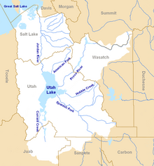
The Provo River (Ute: Timpanoquint, “Rock River)[4] is located in Utah County and Wasatch County, Utah, in the United States. It rises in the Uinta Mountains at Wall Lake and flows about 71 miles (114 km) southwest to Utah Lake at the city of Provo, Utah.

- ^ a b c "Provo River". Geographic Names Information System. United States Geological Survey. December 31, 1979. Retrieved March 11, 2009.
- ^ Source elevation derived from Google Earth search using GNIS source coordinates.
- ^ a b c "Water-data report 2007: 10163000 Provo River at Provo, UT" (PDF). United States Geological Survey. Retrieved March 11, 2009.
- ^ "Explore Native names for familiar Utah places - @theU". attheu.utah.edu. Retrieved 2023-04-19.
© MMXXIII Rich X Search. We shall prevail. All rights reserved. Rich X Search

