Highway 156 | |||||||||
|---|---|---|---|---|---|---|---|---|---|
| Ruta 156 | |||||||||
| Route information | |||||||||
| Maintained by Puerto Rico DTPW | |||||||||
| Length | 58.7 km[1] (36.5 mi) | ||||||||
| Existed | 1953[2]–present | ||||||||
| Major junctions | |||||||||
| West end | |||||||||
| |||||||||
| East end | |||||||||
| Location | |||||||||
| Country | United States | ||||||||
| Territory | Puerto Rico | ||||||||
| Municipalities | Orocovis, Barranquitas, Comerío, Aguas Buenas, Caguas | ||||||||
| Highway system | |||||||||
| |||||||||
| |||||||||


Puerto Rico Highway 156 (PR-156) is a long east–west highway which connects Caguas to Orocovis, passing through Aguas Buenas, Comerío and Barranquitas. This route extends from its junction with PR-1 in downtown Caguas to PR-5155 in downtown Orocovis.[3][4]
-
 Comerío to Barranquitas Road (currently PR-156)
 -
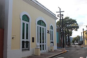 Calle Betances (PR-156) in Caguas barrio-pueblo


- ^ Cite error: The named reference
Google PR-156was invoked but never defined (see the help page). - ^ "Comerío, Memoria Núm. 41" (PDF). Puerto Rico Planning Board (in Spanish). 1955. Retrieved 4 August 2020.
- ^ National Geographic Maps (2011). Puerto Rico (Map). 1:125,000. Adventure Map (Book 3107). Evergreen, Colorado: National Geographic Maps. ISBN 978-1566955188. OCLC 756511572.
- ^ "Tránsito Promedio Diario (AADT)". Transit Data (Datos de Transito) (in Spanish). DTOP PR. pp. 84–85. Archived from the original on 1 April 2019.
© MMXXIII Rich X Search. We shall prevail. All rights reserved. Rich X Search