| Putah Creek | |
|---|---|
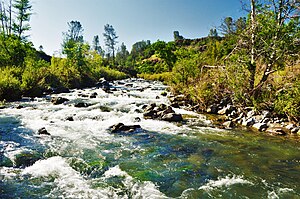
 Putah Creek above Monticello Dam | |
| Native name | Liwaito (Patwin) |
| Location | |
| Country | United States |
| State | California |
| Counties | Yolo, Solano, Napa, Lake |
| Physical characteristics | |
| Source | Cobb Mountain |
| • coordinates | 38°48′26″N 122°43′21″W / 38.80722°N 122.72250°W[1] |
| • elevation | 3,651 ft (1,113 m) |
| Mouth | Yolo Bypass |
• location | Prospect Slough in Yolo Bypass |
• coordinates | 38°30′56″N 121°35′20″W / 38.51556°N 121.58889°W |
• elevation | 7.5 ft (2.3 m) |
| Length | 85 mi (137 km)[2] |
| Basin size | 638 sq mi (1,650 km2) |
| Discharge | |
| • location | near Winters, CA |
| • average | 477 cu ft/s (13.5 m3/s) |
| • minimum | 0 cu ft/s (0 m3/s) |
| • maximum | 81,000 cu ft/s (2,300 m3/s) |


Putah Creek (Patwin: Liwaito[3]) is a major stream in Northern California, a tributary of the Yolo Bypass, and ultimately, the Sacramento River. The 85-mile-long (137 km)[2] creek has its headwaters in the Mayacamas Mountains, a part of the Coast Range, and flows east through two dams. First, Monticello Dam forms Lake Berryessa, below which Putah Creek forms the border of Yolo and Solano Counties, and then flows to the Putah Diversion Dam and Lake Solano. After several drought years in the late 1980s, the majority of Putah Creek went dry, prompting a landmark lawsuit that resulted in the signing of the Putah Creek Accord in 2000. The Accord established releases from the dams to maintain stream flows in Putah Creek, with natural flow regimes which spike in winter/spring and ebb in summer/fall. The restoration of natural flow regimes has resulted in a doubling of riparian bird species and a return of spawning native steelhead trout and Chinook salmon, as well as protecting the livelihood of farmers on the lower watershed.[4][5]
- ^ U.S. Geological Survey Geographic Names Information System: Putah Creek
- ^ a b U.S. Geological Survey. National Hydrography Dataset high-resolution flowline data. The National Map, accessed March 10, 2011
- ^ Smithsonian Institution, Bureau of American Ethnology, Handbook of American Indians North of Mexico (1906), pt. 1, p.711
- ^ Kristen E. Dybala; Andrew Engilis Jr.; John A. Trochet; Irene E. Engilis; Melanie L. Truan (March 2018). "Evaluating Riparian Restoration Success: Long-Term Responses of the Breeding Bird Community in California's Lower Putah Creek Watershed". Ecological Restoration. Retrieved March 17, 2018.
- ^ Joseph D. Kiernan; Peter B. Moyle; Patrick K. Crain (July 2012). "Restoring native fish assemblages to a regulated California stream using the natural flow regime concept" (PDF). Ecological Applications. 22 (5): 1472–1482. doi:10.1890/1051-0761-22.5.1472. PMID 22908707. Retrieved March 17, 2018.
© MMXXIII Rich X Search. We shall prevail. All rights reserved. Rich X Search

