Back Glacera Quelccaya Catalan Quelccaya-Eiskappe German Glaciar Quelccaya Spanish یخچال کوئلکایا Persian Calotte glaciaire de Quelccaya French Quelccaya-gleccser Hungarian Calota de gelo de Quelccaya Portuguese Qillqaya Rit'ipampa Quechua Ledena kapa Quelccaya Serbo-Croatian
| Quelccaya | |
|---|---|
| Quenamari | |
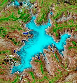
 November 2022 satellite image of the glacier by Sentinel-2. | |
| Type | Ice cap |
| Location | Peru |
| Coordinates | 13°55′30″S 70°49′03″W / 13.92500°S 70.81750°W[1] |
| Area | 42.8 sq km (16.5 sq mi) in 2009 |
| Length | 17 km |
| Width | 3-5 km |
| Thickness | 100-150 m (200 m at thickest) |
| Highest elevation | 5,700 m |
| Lowest elevation | 5,200 m |
| Status | Retreating |
The Quelccaya Ice Cap (also known as Quenamari Ice Cap) is the second largest glaciated area in the tropics, after Coropuna. Located in the Cordillera Oriental section of the Andes mountains in Peru, the cap covers an area of 42.8 square kilometres (16.5 sq mi) with ice up to 200 metres (660 ft) thick. It is surrounded by tall ice cliffs and a number of outlet glaciers, the largest of which is known as Qori Kalis Glacier; lakes, moraines, peat bogs and wetlands are also present. There is a rich flora and fauna, including birds that nest on the ice cap. Quelccaya is an important source of water, eventually melting and flowing into the Inambari and Vilcanota Rivers.
A number of ice cores have been obtained from Quelccaya, including two from 1983 that were the first recovered outside of the polar regions. Past climate states have been reconstructed from data in these ice cores; these include evidence of the Little Ice Age, regional droughts and wet periods with historical significance and past and recent El Niño events. The ice cap is regularly monitored and has a weather station.
Quelccaya was much larger in the past, merging with neighbouring glaciers during the Pleistocene epoch. A secondary expansion occurred during either the Antarctic Cold Reversal or the Younger Dryas climate anomalies. At the beginning of the Holocene the ice cap shrank to a size smaller than present day; around 5,000 years ago, a neoglacial expansion began. A number of moraines – especially in the Huancané valley – testify to past expansions and changes of Quelccaya, although the chronology of individual moraines is often unclear.
After reaching a secondary highstand (area expansion) during the Little Ice Age, Quelccaya has been shrinking due to human-caused climate change; in particular the Qori Kalis Glacier has been retreating significantly. Life and lakes have been occupying the terrain left by retreating ice; these lakes can be dangerous as they can cause floods when they breach. Climate models predict that without climate change mitigation measures, Quelccaya is likely to disappear during the 21st or 22nd century.
- ^ Buffen et al. 2009, p. 158.
© MMXXIII Rich X Search. We shall prevail. All rights reserved. Rich X Search
