| Rajah Sikatuna Protected Landscape | |
|---|---|
IUCN category V (protected landscape/seascape) | |
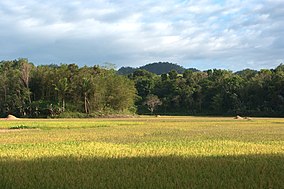
 View of the hills of Rajah Sikatuna Protected Landscape | |
| Location | Bohol, Philippines |
| Nearest city | Tagbilaran |
| Coordinates | 9°42′19″N 124°7′27″E / 9.70528°N 124.12417°E |
| Area | 10,452.6 hectares (25,829 acres) |
| Established | July 10, 1987 (National park) April 23, 2000 (Protected landscape) |
| Governing body | Department of Environment and Natural Resources |
The Rajah Sikatuna Protected Landscape is a protected landscape area of forested limestone hills, grasslands and natural springs in the island province of Bohol in the Central Visayas region of the Philippines. It is the largest remaining tract of natural forest in Bohol and one of the Philippines' top birdwatching sites.[1] The park was initially gazetted a national park in 1987 covering approximately 9,023 hectares (22,300 acres).[2] In 2000, it was reestablished as a protected landscape under the National Integrated Protected Areas System covering its present area of 10,452.6 hectares (25,829 acres).[3] The park is one of the island's major tourist attractions located just south of the famous Chocolate Hills. It was named after the Bohol chieftain who entered into a blood-compact with Spanish conquistador Miguel López de Legazpi on the island in 1565.[1]
- ^ a b "Rajah Sikatuna Protected Landscape, Bohol, Philippines". Birding2Asia. Retrieved 9 November 2014.
- ^ "Proclamation No. 129, s. 1987". Official Gazette of the Republic of the Philippines. Retrieved 9 November 2014.
- ^ "Proclamation No. 287, s. 2000". Official Gazette of the Republic of the Philippines. Retrieved 9 November 2014.
© MMXXIII Rich X Search. We shall prevail. All rights reserved. Rich X Search

