Back منطقة رايجادا Arabic رايجادا ARZ রায়গড়া জেলা Bengali/Bangla Rayagada (distrito sa Indiya) CEB Rayagada (Distrikt) German Distrito de Rayagada Spanish Rayagada barrutia Basque بخش رایاگادا Persian Rayagadan piirikunta Finnish District de Rayagada French
Rayagada district | |
|---|---|
 Location in Odisha | |
| Coordinates: 19°09′58″N 83°24′58″E / 19.166°N 83.416°E | |
| Country | |
| State | |
| Headquarters | Rayagada |
| Government | |
| • Collector & District Magistrate | Swadha Dev Singh, IAS |
| • Superintendent of Police | Vivekanand Sharma, IPS |
| • Divisional Forest Officer, Rayagada Forest Division | Aswini Kumar Kar, OFS |
| Area | |
| • Total | 7,584.7 km2 (2,928.5 sq mi) |
| Population (2011) | |
| • Total | 967,911 |
| • Density | 116/km2 (300/sq mi) |
| Languages | |
| • Official | Odia, English |
| • Local | Kui, Sora, Kuvi |
| Time zone | UTC+5:30 (IST) |
| PIN | 765 xxx |
| Vehicle registration | OD-18 |
| Sex ratio | 0.972 ♂/♀ |
| Literacy | 49.76% |
| Lok Sabha constituency | Koraput(ST) |
| Vidhan Sabha constituency |
|
| Municipality | |
| Notified Area Council (NAC) | Gudari NAC |
| Website | www |
| This article is part of a series on |
| Odisha |
|---|
 |
| Governance |
| Topics |
|
Districts Divisions |
| GI Products |
|
|

Rayagada district is a district in southern Odisha, a state in India, which became a separate district in October 1992. Its population consists mainly of tribes, primarily the Khonds and the Soras. In addition to Odia, Kui and Sora are spoken by the district's indigenous population. It was founded by Maharajah Biswanatha Deba Gajapati of the Surjyabansha dynasty of Jeypore.[1][2][3][4]
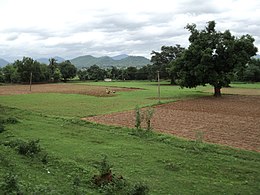
Rayagada covers an area of 7,584.7 square kilometres (2,928.5 sq mi), and is divided into eleven blocks. Agriculture is the chief source of income, and paddy, wheat, ragi, green and black gram, groundnut, sweet potato and maize are the district's major crops.
- ^ Schnepel 1995, p. 147.
- ^ KBS Singh 1939, p. 19.
- ^ Mohanty 2013.
- ^ Sarma, G. v Prasada (24 May 2017). "Shedding light on tribal history and culture". The Hindu.
© MMXXIII Rich X Search. We shall prevail. All rights reserved. Rich X Search

