Back ردينغ (كاليفورنيا) Arabic ريدينج (كاليفورنيا) ARZ ردینق، کالیفورنیا AZB Рэдынг (Каліфорнія) Byelorussian Рединг (Калифорния) Bulgarian Redding (Califòrnia) Catalan Реддинг (Калифорни) CE Redding CEB Redding (Kalifornie) Czech Redding DAG
Redding, California | |
|---|---|
|
Top: Sundial Bridge at Turtle Bay; middle: Cascade Theatre, Hotel Lorenz; bottom: Old City Hall, Pine Street School | |
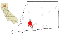
 Location of Redding in Shasta County, California | |
| Coordinates: 40°35′11″N 122°23′30″W / 40.58639°N 122.39167°W | |
| Country | United States |
| State | California |
| County | Shasta |
| Incorporated | October 4, 1887 |
| Founded by | Pierson B. Reading |
| Government | |
| • Type | Council-manager |
| • Mayor | Tenessa Audette |
| Area | |
• Total | 61.17 sq mi (158.44 km2) |
| • Land | 59.65 sq mi (154.48 km2) |
| • Water | 1.53 sq mi (3.96 km2) 2.50% |
| Elevation | 564 ft (172 m) |
| Population (2020) | |
• Total | 93,611 |
| • Rank | 83rd in California |
| • Density | 1,500/sq mi (590/km2) |
| Demonym | Reddingite |
| Time zone | UTC−08:00 (PST) |
| • Summer (DST) | UTC−07:00 (PDT) |
| ZIP codes | 96001–96003, 96049, 96099 |
| Area code | 530 |
| FIPS code | 06-59920 |
| GNIS feature IDs | 277582, 2411531 |
| Website | Official website |
Redding is the county seat of Shasta County, California, and the economic and cultural capital of the Shasta Cascade region of Northern California. Redding lies along the Sacramento River, 162 miles (261 km) north of Sacramento, and 120 miles (190 km) south of California's northern border with Oregon. Its population is 95,542 as of 2022, up from 93,611 at the 2020 census.[3]
- ^ "2019 U.S. Gazetteer Files". United States Census Bureau. Archived from the original on January 16, 2020. Retrieved July 1, 2020.
- ^ "Redding". Geographic Names Information System. United States Geological Survey, United States Department of the Interior. Retrieved November 22, 2014.
- ^ "Geography Profile: Redding city, California". Census.gov. Retrieved January 7, 2024.
© MMXXIII Rich X Search. We shall prevail. All rights reserved. Rich X Search


