Back مناطق الفلبين Arabic Regiona vo de Philippinen BAR Rehiyon kan Filipinas BCL Regions de les Filipines Catalan Rehiyon (Pilipinas) CEB Filippinernes regioner Danish Region (Philippinen) German Anexo:Regiones de Filipinas Spanish Filippiinien alueet Finnish מחוזות הפיליפינים HE
| Regions of the Philippines | |
|---|---|
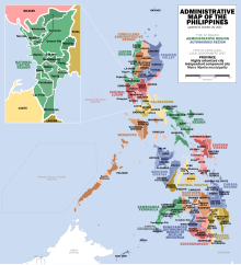
 Administrative Map of the Philippines | |
| Category | Region |
| Location | Philippines |
| Number | 17 (as of 2019) |
| Possible status |
|
| Populations | Smallest: 1,791,121 (CAR) Largest: 16,139,770 (Calabarzon) |
| Areas | Smallest: 619.57 km2 (239.22 sq mi) (NCR) Largest: 29,620.90 km2 (11,436.69 sq mi) (Mimaropa) |
| Government |
|
| Subdivisions | |
 |
|---|
|
|
In the Philippines, regions (Filipino: rehiyon; ISO 3166-2:PH) are administrative divisions that primarily serve to coordinate planning and organize national government services across multiple local government units (LGUs). Most national government offices provide services through their regional branches instead of having direct provincial or city offices. Regional offices are usually but not necessarily located in the city designated as the regional center.
As of 2019, the Philippines is divided into 17 regions. Sixteen of these are mere administrative groupings, each provided by the president of the Philippines with a regional development council (RDC) – in the case of the National Capital Region (Metro Manila), an additional metropolitan authority serves as the coordinating and policy-making body. Only one, the Bangsamoro Autonomous Region in Muslim Mindanao, has an elected government and parliament to which the Congress of the Philippines has delegated certain powers and responsibilities.
© MMXXIII Rich X Search. We shall prevail. All rights reserved. Rich X Search