Back ريمينغتون (فرجينيا) Arabic Remington (Virgínia) Catalan Ремингтон (Виргини) CE Remington (lungsod sa Tinipong Bansa, Virginia) CEB Remington, Virginia Welsh Remington (Virginia) Spanish Remington (Virginie) French Remington, Vijini HT Remington (Virginia) Italian Remington (Virginia) LLD
Remington, Virginia | |
|---|---|
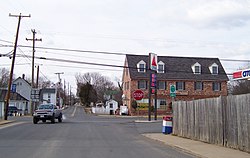
 Central Remington | |
 Location of Remington, Virginia | |
| Coordinates: 38°32′8″N 77°48′29″W / 38.53556°N 77.80806°W | |
| Country | United States |
| State | Virginia |
| County | Fauquier |
| Area | |
| • Total | 0.22 sq mi (0.57 km2) |
| • Land | 0.22 sq mi (0.57 km2) |
| • Water | 0.00 sq mi (0.00 km2) |
| Elevation | 272 ft (83 m) |
| Population (2010) | |
| • Total | 598 |
| • Estimate (2019)[2] | 658 |
| • Density | 3,004.57/sq mi (1,159.28/km2) |
| Time zone | UTC−5 (Eastern (EST)) |
| • Summer (DST) | UTC−4 (EDT) |
| ZIP code | 22734 |
| Area code | 540 |
| FIPS code | 51-66512[3] |
| GNIS feature ID | 1499948[4] |
| Website | www |
Remington is a small incorporated town in Fauquier County, Virginia, United States. The population was 598 at the 2010 census. It is near the highways, U.S. Route 15, U.S. Route 17, U.S. Route 29, and Virginia State Route 28. Remington is less than a mile northeast of the Culpeper County line.
- ^ "2019 U.S. Gazetteer Files". United States Census Bureau. Retrieved August 7, 2020.
- ^ Cite error: The named reference
USCensusEst2019CenPopScriptOnlyDirtyFixDoNotUsewas invoked but never defined (see the help page). - ^ "U.S. Census website". United States Census Bureau. Retrieved January 31, 2008.
- ^ "US Board on Geographic Names". United States Geological Survey. October 25, 2007. Retrieved January 31, 2008.
© MMXXIII Rich X Search. We shall prevail. All rights reserved. Rich X Search
