| Rio Grande Valley | |
|---|---|
| Valle de Río Grande (Spanish) | |
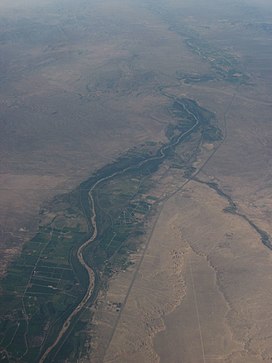
 Rio Grande Valley near Socorro, New Mexico | |
| Length | 230 mi (370 km) N-S |
| Geology | |
| Type | River valley |
| Age | 2.06 Ma |
| Geography | |
| Country | United States |
| State | New Mexico |
| Population centers | |
| Borders on | New Mexico-Texas (3 mi (4.8 km)) |
| Coordinates | 33°41′52.41″N 106°57′19.78″W / 33.6978917°N 106.9554944°W |
| River | Rio Grande |
The Rio Grande Valley is the river valley carved out by the Rio Grande as it flows through the American Southwest and northeastern Mexico, forming a part of the border region. In the US state of New Mexico, the river flows mostly north to south, and forms a valley near Cochiti Pueblo[1] to the state line near El Paso, Texas along the floors of the large sedimentary basins of the Rio Grande Rift, and includes the narrow sections between the basins. It has been historically settled first by the Pueblo peoples, the Spanish, the Mexicans, and finally Anglo-Americans. As the largest river in the state, some of its most populous cities are located wholly or partially in the valley, including Albuquerque, New Mexico's largest city.
The Rio Grande Valley is vital to the state's surface and groundwater municipal water supply, recreation, and agriculture, including irrigated farmland, the Rio Grande Valley AVA, the Mesilla Valley AVA, and the largest acreages of land for growing chile peppers and pecans in the United States, accounting for 77% and 14% of US production, respectively.[2][3]
- ^ "Rio Grande Valley, New Mexico". e-Hillerman. University of New Mexico. Retrieved March 16, 2021.
- ^ "2019 New Mexico Agricultural Statistics" (PDF). New Mexico Department of Agriculture; USDA. Retrieved February 5, 2021.
- ^ "The New Mexico Pecan Industry Today". NMSU College of Agricultural, Consumer and Environmental Sciences (ACES). New Mexico State University. Retrieved March 17, 2021.
© MMXXIII Rich X Search. We shall prevail. All rights reserved. Rich X Search
