Back نهر كولن (نهر) ARZ Río Colne Spanish Colne (Yorkshire de l'Ouest) French Rio Colne Portuguese Colne, West Yorkshire Serbo-Croatian
| River Colne | |
|---|---|
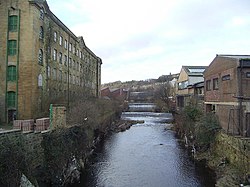
 The River Colne at the bottom of Chapel Hill just outside Huddersfield Town Centre. The mill on the left is Folly Hall Mill built in 1822 by Joseph Kaye. | |
| Location | |
| Country | England |
| Physical characteristics | |
| Source | |
| • location | Confluence of Redbrook Clough and Haigh Clough |
| • coordinates | 53°36′19″N 1°57′28″W / 53.60528°N 1.95778°W |
| • elevation | 768 feet (234 m) |
| Mouth | |
• location | River Calder near Bradley |
• coordinates | 53°40′49″N 1°43′52″W / 53.68028°N 1.73111°W |
| Length | 12 miles (19 km)[1] |
| Basin size | 95 square miles (245 km2) |
The River Colne /ˈkoʊn/ in West Yorkshire is formed at the confluence of two brooks that originate in the Pennines close to Marsden. It flows in an easterly direction through the Colne Valley and Huddersfield towards Cooper Bridge where it flows into the River Calder.
- ^ Ekwall, Eilert (1968). English River Names. Oxford: Clarendon Press. p. 90. ISBN 9780198691198.
© MMXXIII Rich X Search. We shall prevail. All rights reserved. Rich X Search