Back نهر رودنچ ARZ River Roding CEB Родинг (юханшыв) CV River Roding German Abhainn Roding Irish Roding i England NN Roding (England) NB Roding (rzeka) Polish Родинг (река) Russian Roding (rijeka) Serbo-Croatian
| Roding (Barking Creek) | |
|---|---|
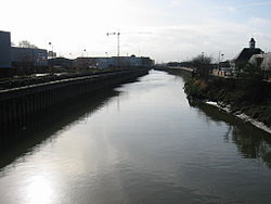
 The Roding, just before reaching the Thames at Barking | |
| Location | |
| Country | England |
| Counties | Essex, Greater London |
| Districts / Boroughs | Epping Forest, Uttlesford, Redbridge, Newham, Barking and Dagenham |
| Towns | The Rodings, Chipping Ongar, Loughton, Woodford Green, Ilford, Barking |
| Physical characteristics | |
| Source | |
| • location | Molehill Green, Essex |
| • coordinates | 51°53′57″N 0°16′40″E / 51.8993°N 0.2778°E |
| • elevation | 93 m (305 ft) |
| Mouth | River Thames |
• location | Creekmouth |
• coordinates | 51°30′51″N 0°05′57″E / 51.5142°N 0.0993°E |
• elevation | 0 m (0 ft) |
| Length | 50 km (31 mi) |
| Discharge | |
| • location | Redbridge |
| • average | 1.85 m3/s (65 cu ft/s) |
| • minimum | 0.08 m3/s (2.8 cu ft/s)13 August 1990 |
| • maximum | 62.4 m3/s (2,200 cu ft/s)22 November 1974 |
| Discharge | |
| • location | Loughton |
| • average | 1.41 m3/s (50 cu ft/s) |
| Discharge | |
| • location | High Ongar |
| • average | 0.48 m3/s (17 cu ft/s) |
The River Roding (/ˈroʊdɪŋ/) rises at Molehill Green, Essex, England, then flows south through Essex and London and forms Barking Creek as it reaches the River Thames.
© MMXXIII Rich X Search. We shall prevail. All rights reserved. Rich X Search