Back نهر الترينت Arabic نهر الترينت ARZ ترنت چایی AZB River Trent BAR Трэнт (рака) Byelorussian Трент Bulgarian ট্রেন্ট নদী Bengali/Bangla Trent (stêr) Breton Trent (rijeka) BS Trent (riu) Catalan
| River Trent | |
|---|---|
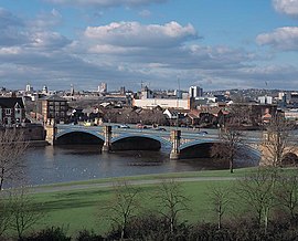
 Trent Bridge, with Nottingham in the background | |
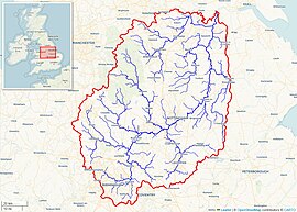
 Drainage basin of the River Trent (Interactive map) | |
| Location | |
| Country | United Kingdom |
| Country within the UK | England |
| Counties | Staffordshire, Derbyshire, Leicestershire, Nottinghamshire, Lincolnshire, Yorkshire |
| Cities | Stoke-on-Trent, Nottingham |
| Towns | Stone, Rugeley, Burton upon Trent, Newark-on-Trent, Gainsborough |
| Physical characteristics | |
| Source | |
| • location | Biddulph Moor, Staffordshire, England |
| • coordinates | 53°06′58″N 02°08′25″W / 53.11611°N 2.14028°W |
| • elevation | 275 m (902 ft) |
| Mouth | |
• location | Trent Falls, Humber Estuary, Lincolnshire, England |
• coordinates | 53°42′03″N 00°41′28″W / 53.70083°N 0.69111°W |
• elevation | 0 m (0 ft) |
| Length | 298 km (185 mi) |
| Basin size | 10,435 km2 (4,029 sq mi)[1][a] |
| Discharge | |
| • location | Colwick[3] |
| • average | 84 m3/s (3,000 cu ft/s)[3] |
| • minimum | 15 m3/s (530 cu ft/s)[3][b] |
| • maximum | 1,018 m3/s (36,000 cu ft/s)[4][c] |
| Discharge | |
| • location | North Muskham |
| • average | 88 m3/s (3,100 cu ft/s) |
| Basin features | |
| Tributaries | |
| • left | Blithe, Swarbourn, Dove, Derwent, Erewash, Leen, Greet, Idle, Torne |
| • right | Sow, Tame, Mease, Soar, Devon, Eau |
| Progression : River Trent — Humber — North Sea | |

The Trent is the third longest river in the United Kingdom. Its source is in Staffordshire, on the southern edge of Biddulph Moor. It flows through and drains the North Midlands into the Humber Estuary. The river is known for dramatic flooding after storms and spring snowmelt, which in the past often caused the river to change course.
The river passes through Stoke-on-Trent, Stone, Staffordshire, Rugeley, Burton-upon-Trent and Nottingham before joining the River Ouse, Yorkshire at Trent Falls to form the Humber Estuary, which empties into the North Sea between Kingston upon Hull in Yorkshire and Immingham in Lincolnshire. The wide Humber estuary has often been described as the boundary between the Midlands and the north of England.[5][6]
- ^ Trent River Authority. Official Handbook of the Trent River Authority. Cheltenham and London:Ed. J. Burrow and Co. Ltd, 1972.
- ^ "Midlands Catchment Flood Management Plans". Environment Agency. December 2009. Retrieved 11 April 2013.
- ^ a b c "28009 – Trent at Colwick". The National River Flow Archive. Centre for Ecology & Hydrology. Retrieved 24 March 2013.
- ^ "Hi Flows UK". Environment Agency. Retrieved 4 March 2013.
- ^ James R. Penn (2001). Rivers of the World: A Social, Geographical, and Environmental Sourcebook. ABC-CLIO. pp. 107–8. ISBN 978-1-57607-042-0.
- ^ Clare Bambra (30 August 2016). Health Divides: Where You Live Can Kill You. Policy Press. pp. 73–6. ISBN 978-1-4473-3035-6.
Cite error: There are <ref group=lower-alpha> tags or {{efn}} templates on this page, but the references will not show without a {{reflist|group=lower-alpha}} template or {{notelist}} template (see the help page).
© MMXXIII Rich X Search. We shall prevail. All rights reserved. Rich X Search