Back River Twiss CEB River Twiss German ریور تویس Persian Twiss (rivier) Dutch River Twiss Swedish Ревир туис Tajik
| River Twiss | |
|---|---|
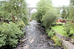
 River Twiss and Ingleton Viaduct | |
| Location | |
| Country | England |
| Physical characteristics | |
| Source | |
| • location | Kingsdale Beck, Keld Head |
| • coordinates | 54°11′3″N 2°28′4″W / 54.18417°N 2.46778°W |
| • elevation | 264 metres (866 ft) |
| Mouth | |
• location | River Doe |
• coordinates | 54°9′11″N 2°28′15″W / 54.15306°N 2.47083°W |
• elevation | 118 metres (387 ft) |
| Length | 4.17 kilometres (2.59 mi) |
The River Twiss is a river in the county of Yorkshire, England. The source of the river is Kingsdale Beck, which rises at Kingsdale Head at the confluence of Back Gill and Long Gill in the Yorkshire Dales. Beneath Keld Head, the river changes its name to the River Twiss. It has two notable waterfalls, Thornton Force and Pecca Falls, and its course follows part of the Ingleton Waterfalls Walk,[1] then through Swilla Glen to Thornton in Lonsdale and down to Ingleton, where it meets the River Doe to form the River Greta.
The English landscape artist J. M. W. Turner was a frequent visitor to the area, and his sketch of Thornton Force in 1816 is currently part of the Tate collection.[2]
- ^ "Ingleton Waterfalls Walk". Archived from the original on 2 October 2011. Retrieved 20 August 2011.
- ^ "Landscape". Retrieved 20 August 2011.
© MMXXIII Rich X Search. We shall prevail. All rights reserved. Rich X Search