Back Propinsi Romblon ACE رومبلون Arabic رومبلون AZB Romblon BCL Romblon CBK-ZAM Romblon CEB Provinz Romblon German Provincia de Romblón Spanish رومبلون Persian Romblon Finnish
Romblon | |
|---|---|
| Province of Romblon | |
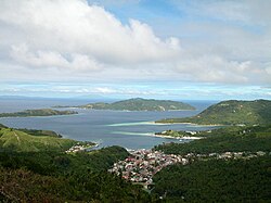
(From top, left to right) Romblon Bay and town, Fort San Andres, the Romblon Marble Sign, Mainit Falls in Odiongan, Binucot Beach in Odiongan and Mount Guiting-Guiting. | |
| Nickname: Marble Capital of the Philippines | |
 Location in the Philippines | |
| Coordinates: 12°33′N 122°17′E / 12.55°N 122.28°E | |
| Country | Philippines |
| Region | Mimaropa |
| Founded | 16 March 1901 |
| First annexation to Capiz | 2 July 1907 |
| Reestablished | 22 February 1918[1] |
| Second annexation to Capiz | 30 September 1942 |
| Restored | 1 October 1946 |
| Capital | Romblon |
| Largest Municipality | Odiongan |
| Government | |
| • Type | Sangguniang Panlalawigan |
| • Governor | Jose R. Riano (PFP) |
| • Vice Governor | Armando Gutierrez (PDP–Laban) |
| • Representative | Eleandro Jesus F. Madrona (NP) |
| • Legislature | Romblon Provincial Board |
| Area | |
| • Total | 1,533.45 km2 (592.07 sq mi) |
| • Rank | 68th out of 81 |
| Highest elevation | 2,058 m (6,752 ft) |
| Population (2020 census)[3] | |
| • Total | 308,985 |
| • Rank | 66th out of 81 |
| • Density | 200/km2 (520/sq mi) |
| • Rank | 46th out of 81 |
| Divisions | |
| • Independent cities | 0 |
| • Component cities | 0 |
| • Municipalities | |
| • Barangays | 219 |
| • Districts | Legislative district of Romblon |
| Time zone | UTC+08:00 (PHT) |
| ZIP Code | 5500–5515 |
| IDD : area code | +63 (0)42 |
| ISO 3166 code | PH-ROM |
| Spoken languages | |
| Website | romblonparadise |
Romblon (/rɒmˈbloʊn/ rom-BLOHN, Tagalog: [ɾomˈblon]), officially the Province of Romblon, is an archipelagic province of the Philippines located in the Mimaropa region. Its main components include Romblon, Romblon, an archipelagic municipality of the same name that also serves as the provincial capital; Tablas, the largest island, covering nine municipalities; Sibuyan with its three towns; as well as the smaller island municipalities of Corcuera, Banton, Concepcion, San Jose. The province lies south of Marinduque and Quezon, east of Oriental Mindoro, north of Aklan and Capiz, and west of Masbate. According to the 2020 census, it has a total population of 308,985.[3]
Romblon has been inhabited by aboriginal Filipinos prior to the arrival of the Spanish in 1569. Archaeological artifacts recovered by the National Museum in 1936 indicate that the aborigines of Romblon already have a rich and advanced culture. During the Spanish colonial rule, Romblon was initially administered under the province of Arevalo (Iloilo) until 1716, when it was transferred to the jurisdiction of the newly created province of Capiz. With arrival of the Americans in 1901, Romblon was declared a province and placed under civilian rule. It lost its provincial status for a short while between 1907 and 1945, but regained it in 1946, just after World War II.
The inhabitants of Romblon are divided into three ethnolinguistic groups: Romblomanon, Onhan and Asi. These groups occupy specific islands in the province and have their own language and customs. Romblomanon is mainly spoken in the town of Romblon, in all of three towns of Sibuyan Island, and the town of San Agustin in Tablas. Onhan is mainly spoken in the municipalities in the southern part of Tablas (Alcantara, Looc, Ferrol, Santa Fe, San Andres, and Santa Maria), as well as in the island municipality of San Jose. The northwestern part of Tablas Island (in Odiongan and Calatrava, as well as the islands municipalities of Corcuera, Banton, and Concepcion), speaks the Asi language.
The province relies on agriculture, particularly rice and copra farming as well as fishing, for its livelihood. It also has a lucrative marble industry due to an abundance of Italian-quality marble, hence, its moniker as the "Marble Capital of the Philippines."[4] The islands of the province have a number of white sand beaches, diving spots, mountains and rainforests that tourists visit. Sibuyan island is an ecotourism destination, having been dubbed by some as "the Galápagos of Asia" because it has remained in isolation from the rest of the world since its formation.[5]
- ^ "Executive Order No. 5, series of 1918". Official Gazette. XVI (13): 520. 27 March 1918. Retrieved 6 June 2023.
- ^ "List of Provinces". PSGC Interactive. Makati City, Philippines: National Statistical Coordination Board. Retrieved 31 January 2013.
- ^ a b Census of Population (2020). Table B - Population and Annual Growth Rates by Province, City, and Municipality - By Region. Philippine Statistics Authority. Retrieved 8 July 2021.
- ^ "ROMBLON ISLAND TRAVEL GUIDE: The Marble Capital of the Philippines". outoftownblog.com. Retrieved December 24, 2023.
- ^ "7 'Galapagos Islands' from around the world". wanderlust.co.uk. Retrieved December 24, 2023.
© MMXXIII Rich X Search. We shall prevail. All rights reserved. Rich X Search


