| Rose Canyon Fault | |
|---|---|
| Rose Canyon Fault Zone, Newport Inglewood-Rose Canyon Fault Zone, Newport Inglewood-Rose Canyon-Vallecitos-San Miguel Fault Zone, Newport Inglewood-Rose Canyon-Descanso-Agua Blanca Fault Zone | |
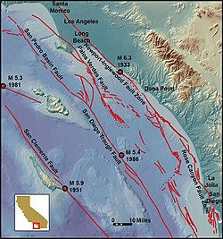
 The Rose Canyon Fault is located at the bottom right of the map | |
| Etymology | Rose Canyon |
| Location | Onshore and offshore San Diego |
| Country | United States |
| State | California |
| Characteristics | |
| Part of | California Continental Borderland |
| Length | ~30–170 km (19–106 mi) |
| Tectonics | |
| Earthquakes | 1862 San Diego earthquake |
| Type | Right-lateral strike-slip |

The Rose Canyon Fault is a right-lateral strike-slip fault that runs in a north–south direction off the coast of San Diego County, California until it comes ashore near downtown San Diego. The fault is linked to the Newport–Inglewood Fault (NIFZ) in the north and either the Agua Blanca Fault or San Miguel–Vallecitos Fault Zone in the south via en echelon step overs. Conservative estimates of the fault place the length around 30–50 km (19–31 mi), while interpretations including the NIFZ place the length at 170 km (110 mi). There are not many earthquakes associated with the fault, however a magnitude 6–6.5 may have struck on the fault in 1862. The fault runs very near to populated areas when offshore, hence there is high potential for infrequent large and damaging earthquakes.
© MMXXIII Rich X Search. We shall prevail. All rights reserved. Rich X Search
