Back Ruyan (distrito) CBK-ZAM Ruyan (Region) German Ruyan (distrito) Spanish رویان (تبرستان) Persian Ruyan (distri) HT Ruyan (regione storica) Italian Ruyan (district) SIMPLE Ruyan Swedish 鲁彦 (伊朗) Chinese

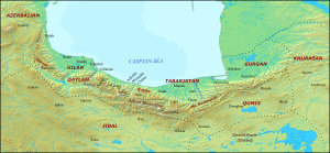
Ruyan (Persian: رویان), later known as Rustamdar (رستمدار), was the name of a mountainous district that encompassed the western part of Tabaristan/Mazandaran, a region on the Caspian coast of northern Iran.[a]
In Iranian mythology, Ruyan appears as one of the places that the legendary archer Arash shot his arrow from, reaching the edge of Khorasan to mark the border between Iran and Turan. The region first appears in historical records as one of the lands of king Gushnasp and his descendants, who served as Sasanian vassals, until they were deposed by the King of Kings (shahanshah) Kavad I (r. 488–496, 498–531).
During the Arab invasion of Iran, the last shahanshah Yazdegerd III (r. 632–651) reportedly granted control over Tabaristan to the Dabuyid ruler Gil Gavbara, who was a great-grandson of shahanshah Jamasp (r. 496–498/9). Gil Gavbara's son Baduspan I was granted control over Ruyan in 665, thus forming the Baduspanid dynasty, which would rule the area until its conquest by the Safavids in the 1590s.
Cite error: There are <ref group=lower-alpha> tags or {{efn}} templates on this page, but the references will not show without a {{reflist|group=lower-alpha}} template or {{notelist}} template (see the help page).
© MMXXIII Rich X Search. We shall prevail. All rights reserved. Rich X Search