Back ས་སྐྱ་རྫོང་། Tibetan Sajia Xian CEB Sa’gya German Sa'gya Spanish شهرستان ساگیا Persian Xian de Sa'gya French Contea di Sa'gya Italian サキャ県 Japanese 싸자현 Korean Sakya (arrondissement) Dutch
Sa'gya County
萨迦县 • ས་སྐྱ་རྫོང་། | |
|---|---|
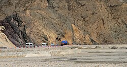
 Friendship Highway in Sa'gya County | |
 Location of Sa'gya County (red) within Shigatse City (yellow) and the Tibet AR | |
| Coordinates (Sa'gya County government): 28°53′59″N 88°01′18″E / 28.8997°N 88.0217°E | |
| Country | China |
| Autonomous region | Tibet |
| Prefecture-level city | Xigazê |
| County seat | Sa'gya |
| Area | |
| • Total | 5,748.81 km2 (2,219.63 sq mi) |
| Population (2020)[1] | |
| • Total | 48,766 |
| • Density | 8.5/km2 (22/sq mi) |
| Time zone | UTC+8 (China Standard) |
| Website | www |
| Sa'gya County | |||||||
|---|---|---|---|---|---|---|---|
| Chinese name | |||||||
| Simplified Chinese | 萨迦县 | ||||||
| Traditional Chinese | 薩迦縣 | ||||||
| |||||||
| Tibetan name | |||||||
| Tibetan | ས་སྐྱ་རྫོང་། | ||||||
| |||||||
Sa'gya County (Tibetan: ས་སྐྱ་རྫོང་།; Chinese: 萨迦县) is a county under the prefecture-level city of Xigazê in the Tibet Autonomous Region, China.[2]
The county is named after Sakya Monastery, home of the Sakya school of Tibetan Buddhism.[3]
- ^ "日喀则市第七次全国人口普查主要数据公报" (in Chinese). Government of Xigazê. 2021-07-20.
- ^ Croddy, E. (2022). China’s Provinces and Populations: A Chronological and Geographical Survey. Springer International Publishing. p. 698. ISBN 978-3-031-09165-0. Retrieved 2024-03-07.
- ^ 中国藏式建筑艺术. 附中英文对照目录 (in Chinese). 四川人民出版社. 1998. p. 39. ISBN 978-7-220-04185-3. Retrieved 2024-03-07.
© MMXXIII Rich X Search. We shall prevail. All rights reserved. Rich X Search

