Back سان جيرفيه ليه با ARZ Saint-Gervais-les-Bains AST Saint-Gervais-les-Bains Catalan Сен-ЖегӀве-ле-Бен CE Saint-Gervais-les-Bains CEB Saint-Gervais-les-Bains Czech Saint-Gervais-les-Bains German Saint-Gervais-les-Bains DIQ Σαιν-Ζερβαί-λε-Μπαιν Greek Saint-Gervais-les-Bains Esperanto
You can help expand this article with text translated from the corresponding article in French. (December 2009) Click [show] for important translation instructions.
|
Saint-Gervais-les-Bains | |
|---|---|
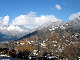
 A general view of Saint-Gervais-les-Bains | |
| Coordinates: 45°53′36″N 6°42′50″E / 45.8933°N 6.7139°E | |
| Country | France |
| Region | Auvergne-Rhône-Alpes |
| Department | Haute-Savoie |
| Arrondissement | Bonneville |
| Canton | Le Mont-Blanc |
| Intercommunality | Pays du Mont-Blanc |
| Government | |
| • Mayor (2020–2026) | Jean-Marc Peillex[1] |
| Area 1 | 63.63 km2 (24.57 sq mi) |
| Population (2021)[2] | 5,602 |
| • Density | 88/km2 (230/sq mi) |
| Time zone | UTC+01:00 (CET) |
| • Summer (DST) | UTC+02:00 (CEST) |
| INSEE/Postal code | 74236 /74170 |
| Elevation | 571–4,810 m (1,873–15,781 ft) |
| 1 French Land Register data, which excludes lakes, ponds, glaciers > 1 km2 (0.386 sq mi or 247 acres) and river estuaries. | |
Saint-Gervais-les-Bains (French pronunciation: [sɛ̃ ʒɛʁvɛ le bɛ̃]) is a commune in the Haute-Savoie department in the Auvergne-Rhône-Alpes region, southeastern France. The village is best known for tourism and has been a popular holiday destination since the early 1900s. It has 445 km (277 mi) of pistes, the third largest domain exclusively in France, and is one of the least busy ski areas of its size.[3] In 1892, two hundred people were killed when a water pocket in a glacier above the town suddenly burst open and caused flooding.
- ^ "Répertoire national des élus: les maires" (in French). data.gouv.fr, Plateforme ouverte des données publiques françaises. 13 September 2022.
- ^ "Populations légales 2021" (in French). The National Institute of Statistics and Economic Studies. 28 December 2023.
- ^ "St Gervais Ski resort information". Freedom Snowsports. Retrieved 30 July 2018.
© MMXXIII Rich X Search. We shall prevail. All rights reserved. Rich X Search


