Back Saint-Valery-en-Caux AST Saint-Valery-en-Caux Catalan Сен-ВалегӀи-ан-Ко CE Saint-Valery-en-Caux CEB Saint-Valery-en-Caux German Saint-Valery-en-Caux Esperanto Saint-Valery-en-Caux Spanish Saint-Valery-en-Caux Basque سنت ولری Persian Saint-Valery-en-Caux Finnish
Saint-Valery-en-Caux | |
|---|---|
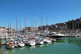
 The marina and town centre | |
| Coordinates: 49°51′40″N 0°42′36″E / 49.861°N 0.710°E | |
| Country | France |
| Region | Normandy |
| Department | Seine-Maritime |
| Arrondissement | Dieppe |
| Canton | Saint-Valery-en-Caux |
| Intercommunality | CC Côte d'Albâtre |
| Government | |
| • Mayor (2020–2026) | Jean-François Ouvry[1] |
| Area 1 | 10.47 km2 (4.04 sq mi) |
| Population (2021)[2] | 3,915 |
| • Density | 370/km2 (970/sq mi) |
| Time zone | UTC+01:00 (CET) |
| • Summer (DST) | UTC+02:00 (CEST) |
| INSEE/Postal code | 76655 /76460 |
| Elevation | 0–80 m (0–262 ft) (avg. 5 m or 16 ft) |
| 1 French Land Register data, which excludes lakes, ponds, glaciers > 1 km2 (0.386 sq mi or 247 acres) and river estuaries. | |
Saint-Valery-en-Caux (French pronunciation: [sɛ̃ valʁi ɑ̃ ko:], literally Saint-Valery in Caux) is a commune in the Seine-Maritime department in the Normandy region in northern France.
The addition of an acute accent on the "e" (Valéry) is incorrect.
- ^ "Répertoire national des élus: les maires". data.gouv.fr, Plateforme ouverte des données publiques françaises (in French). 9 August 2021.
- ^ "Populations légales 2021" (in French). The National Institute of Statistics and Economic Studies. 28 December 2023.
© MMXXIII Rich X Search. We shall prevail. All rights reserved. Rich X Search


