Back Propinsi Salavan ACE سالافان Arabic Salavan (lalawigan) CEB Provinz Salavan German Salavan (wılayet) DIQ Provinco Salavan Esperanto Provincia de Salavan Spanish استان سالاوان Persian Salavan Finnish Province de Saravane French
Salavan province
ແຂວງ ສາລະວັນ | |
|---|---|
 | |
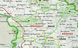
 Map of Salavan province | |
 Location of Salavan province in Laos | |
| Coordinates: 15°52′N 106°21′E / 15.87°N 106.35°E | |
| Country | |
| Capital | Salavan |
| Area | |
| • Total | 10,691 km2 (4,128 sq mi) |
| Population (2020 census) | |
| • Total | 442,200 |
| • Density | 41/km2 (110/sq mi) |
| Time zone | UTC+07 |
| ISO 3166 code | LA-SL |
| HDI (2017) | 0.498[1] low · 16th |
Salavan (also Saravane, Lao: ສາລະວັນ) is a province of Laos, located in the south of the country. Its earlier name was Saravan which was changed by the Thais to Salavan in 1828. It was part of the Champasak Kingdom in an area known as Muang Mang inhabited by minorities of Mon-Khmer groups.[2]
Salavan province covers an area of 16,389 square kilometres (6,328 sq mi). The province borders Savannakhét province to the north, Vietnam to the east, Sekong province to the southeast, Champasak province to the south and Thailand to the west. The central part of the province is located on the Bolaven Plateau, which is a key agricultural area with Arabica coffee as the dominant cash crop. The western part of Salavan province is delimited by the Mekong River while the eastern part is delimited by the Lao-Vietnamese border.
- ^ "Sub-national HDI - Area Database - Global Data Lab". hdi.globaldatalab.org. Retrieved 2018-09-13.
- ^ Burke, Andrew; Vaisutis, Justine (2007). Laos 6th Edition. Lonely Planet. pp. 288–290. ISBN 9781741045680.
© MMXXIII Rich X Search. We shall prevail. All rights reserved. Rich X Search