Back سالينا كروز Arabic سالينا كروز ARZ Salina Cruz (lungsod sa Mehiko, Estado de Oaxaca, Salina Cruz) CEB Salina Cruz German Salina Cruz Esperanto Salina Cruz Spanish Salina Cruz French Salina Cruz Hungarian Salina Cruz ID Salina Cruz Italian
Salina Cruz | |
|---|---|
Municipality and town | |
 | |
 Location of the municipality in Oaxaca | |
| Coordinates: 16°10′N 95°12′W / 16.167°N 95.200°W | |
| Country | Mexico |
| State | Oaxaca |
| Area | |
| • Total | 131.9 km2 (50.9 sq mi) |
| • Town | 31.7 km2 (12.2 sq mi) |
| Population (2020 census)[1] | |
| • Total | 84,438 |
| • Density | 640/km2 (1,700/sq mi) |
| • Town | 76,660 |
| • Town density | 2,400/km2 (6,300/sq mi) |
| Time zone | UTC-6 (Central Standard Time) |
| • Summer (DST) | UTC-5 (Central Daylight Time) |
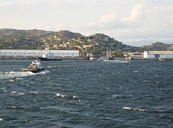
Salina Cruz is a major seaport on the Pacific coast of the Mexican state of Oaxaca. It is the state's fourth-largest city and is the municipal seat of the municipality of the same name. It is part of the Tehuantepec District in the west of the Istmo Region. The city had a 2020 census population of 76,660, while its municipality, with an area of 131.9 km2 (50.9 sq mi) had a population of 84,438, the state's fifth-largest municipality in population.
The port was developed in the late 19th century due to its location at the southern terminus of the Tren Interoceánico, which carried freight across the Isthmus of Tehuantepec.

- ^ Citypopulation.de Population of Salina Cruz municipality with urban localities
© MMXXIII Rich X Search. We shall prevail. All rights reserved. Rich X Search

