Back سالت ریور (کنتاکی) Persian Salt River (Kentucky) Polish Солт (приток Огайо) Russian Солт (дарё) Tajik 索尔特河 (肯塔基州) Chinese
| Salt River | |
|---|---|
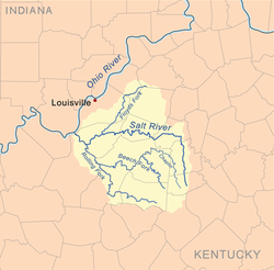
 Salt River watershed | |
| Location | |
| Country | United States |
| Physical characteristics | |
| Source | |
| • location | Parksville, Kentucky |
| • elevation | 500 feet (152 m) |
| Mouth | |
• location | Hardin County, Kentucky |
| Length | 150 miles (240 km) |
| Basin size | Floyds Fork Rolling Fork Beech Fork Chaplin River |
| Discharge | |
| • location | Shepherdsville, Kentucky |
| • average | 1,704 cu/ft. per sec.[1] |
The Salt River is a 150-mile-long (240 km)[2] river in the U.S. state of Kentucky that drains 2,920 square miles (7,600 km2). It begins near Parksville, Kentucky, rising from the north slope of Persimmon Knob south of KY 300 between Alum Springs and Wilsonville, and ends at the Ohio River near West Point. Taylorsville Lake is formed from the Salt River, and Guist Creek Lake is also in its drainage basin.
Annual flooding swells the normally quiet waters to a rapidly flooding torrent, especially along the Rolling Fork, which runs largely along the base of steep, shaly knobs that mark the boundary between the Pennyroyal Region (a Mississippian limestone plateau) to the west and south and the Outer Bluegrass. (See the Ohio River flood of 1937 at Louisville, for an example.) The Taylorsville Lake Dam, built in the early 1970s, has tamed the worst of the floods and changed the nature of the river downstream. Some flooding still occurs, especially near the Brashears Creek confluence at Taylorsville, but it is primarily back flow from the Ohio. The river receives the most rain in the month of May and the least in September, according to data from the local National Weather Service office.
Dams were proposed on the Rolling Fork at Howardstown and on the Beech Fork at Campground, but were not deemed economically feasible. These two tributaries are marked on maps as the Rolling Fork River and the Beech Fork River. A tributary of the Beech Fork, the Chaplin River, rises near the source of the Salt.
- ^ "USGS Surface Water data for Kentucky: USGS Surface-Water Annual Statistics".
- ^ U.S. Geological Survey. National Hydrography Dataset high-resolution flowline data. The National Map, accessed May 13, 2011
© MMXXIII Rich X Search. We shall prevail. All rights reserved. Rich X Search