Back نهر سان غابرييل Arabic نهر سان جابريل ARZ San Gabriel River (Kalifornien) BAR San Gabriel River (Kalifornien) German San Gabriel (fleuve) French סן גבריאל (נהר) HE Сан-Гейбриел (река, впадает в Тихий океан) Russian San Gabriel River SIMPLE 圣盖博河 Chinese
| San Gabriel River | |
|---|---|
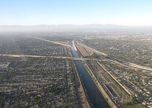
 The channelized San Gabriel River in Los Alamitos, near its confluence with Coyote Creek | |
 Map of the San Gabriel (yellow) and Rio Hondo (purple) watersheds. | |
| Location | |
| Country | United States |
| State | California |
| Counties | Los Angeles County, Orange County |
| Physical characteristics | |
| Source | East Fork San Gabriel River |
| • location | Angeles National Forest, San Gabriel Mountains |
| • coordinates | 34°20′35″N 117°43′30″W / 34.34306°N 117.72500°W[1] |
| • elevation | 4,493 ft (1,369 m) |
| Mouth | Pacific Ocean |
• location | Alamitos Bay, Long Beach/Seal Beach |
• coordinates | 33°44′33″N 118°06′56″W / 33.74250°N 118.11556°W[1] |
• elevation | 0 ft (0 m) |
| Length | 58 mi (93 km)[2] |
| Basin size | 689 sq mi (1,780 km2)[3] |
| Discharge | |
| • location | above Whittier Narrows Dam[4] |
| • average | 185 cu ft/s (5.2 m3/s)[4] |
| • minimum | 0 cu ft/s (0 m3/s) |
| • maximum | 46,600 cu ft/s (1,320 m3/s) |
| Basin features | |
| Tributaries | |
| • left | Walnut Creek, San Jose Creek, Coyote Creek |
| • right | West Fork San Gabriel River |
The San Gabriel River is a mostly-urban waterway flowing 58 miles (93 km)[2] southward through Los Angeles and Orange Counties, California, in the United States. It is the central of three major rivers draining the Greater Los Angeles Area, the others being the Los Angeles River and Santa Ana River. The river's watershed stretches from the rugged San Gabriel Mountains to the heavily-developed San Gabriel Valley and a significant part of the Los Angeles coastal plain, emptying into the Pacific Ocean between the cities of Long Beach and Seal Beach.
The San Gabriel once ran across a vast alluvial flood plain, its channels shifting with winter floods and forming extensive wetlands along its perennial course, a relatively scarce source of fresh water in this arid region. The Tongva and their ancestors inhabited the San Gabriel River basin for thousands of years at villages like Puvunga, relying on the abundant fish and game in riparian habitats. The river is named for the nearby Mission San Gabriel Arcángel, established in 1771 during the Spanish colonization of California. Its water was heavily used for irrigation and ranching by Spanish, Mexican, and American settlers before urbanization began in the early 1900s, eventually transforming much of the watershed into industrial and suburban areas of greater Los Angeles.
Severe floods in 1914, 1934, and 1938 spurred Los Angeles County, and later the federal government, to build a system of dams and debris basins and to channelize much of the lower San Gabriel River with riprap or concrete banks. There is also an extensive system of spreading grounds and other works to capture stormwater runoff and conserve it for urban use. Approximately one-third of the water used in southeast Los Angeles County today comes from the river.
The upper San Gabriel has been intermittently mined for gold since the 1860s, and its deep gravel bed has been an important source of construction aggregate since the early 1900s. The river is also a popular recreation area, with parks and trails in the many flood basins along its course. The headwaters of the San Gabriel River have retained their natural character and are a popular attraction of the Angeles National Forest.
- ^ a b "San Gabriel River". Geographic Names Information System. United States Geological Survey, United States Department of the Interior. January 19, 1981. Retrieved August 22, 2017.
- ^ a b "USGS National Atlas Streamer". United States Geological Survey. Archived from the original on May 28, 2014. Retrieved August 22, 2017.
- ^ Cite error: The named reference
San Gabriel River Watershedwas invoked but never defined (see the help page). - ^ a b "USGS Gage #11087020 San Gabriel River above Whittier Narrows Dam, CA: Water-Data Report 2013" (PDF). National Water Information System. U.S. Geological Survey. 2013. Retrieved August 22, 2017.
© MMXXIII Rich X Search. We shall prevail. All rights reserved. Rich X Search