Back سان بابلو (كاليفورنيا) Arabic سان بابلو (كاليفورنيا) ARZ سان پابلو، کالیفورنیا AZB San Pablo, Kalifornien BAR Сан Пабло Bulgarian San Pablo (Califòrnia) Catalan Сан-Пабло (Калифорни) CE San Pablo (lungsod sa Tinipong Bansa, California) CEB San Pablo (Kalifornie) Czech San Pablo (Kalifornien) German
San Pablo, California | |
|---|---|
 Welcome sign over San Pablo Avenue | |
| Motto: "City of New Directions" | |
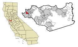
 Location in Contra Costa County and the state of California | |
| Coordinates: 37°57′44″N 122°20′44″W / 37.96222°N 122.34556°W | |
| Country | |
| State | |
| County | Contra Costa |
| Incorporated | April 27, 1948[1] |
| Government | |
| • Mayor | Patricia Ponce[2] |
| • County Board | District 1: John Gioia |
| • State Senator | Nancy Skinner (D)[3] |
| • State Assembly | Buffy Wicks (D)[4] |
| • U. S. Congress | John Garamendi (D)[5] |
| Area | |
| • Total | 2.62 sq mi (6.80 km2) |
| • Land | 2.62 sq mi (6.80 km2) |
| • Water | 0.00 sq mi (0.00 km2) 0% |
| Elevation | 52 ft (16 m) |
| Population (2010) | |
| • Total | 29,139 |
| • Estimate (2019)[7] | 30,990 |
| • Density | 11,810.21/sq mi (4,559.24/km2) |
| Time zone | UTC-8 (PST) |
| • Summer (DST) | UTC-7 (PDT) |
| ZIP code | 94806 |
| Area code(s) | 510, 341 |
| FIPS code | 06-68294 |
| GNIS feature IDs | 1659586, 2411801 |
| Website | sanpabloca.gov |
San Pablo (Spanish for "Saint Paul") is an enclave city in Contra Costa County, California, United States. The population was 32,127 at the 2020 census.[8] The current Mayor is Patricia Ponce. Currently, the City Council consists of Abel Pineda, Arturo Cruz, Elizabeth Pabon-Alvarado, and Rita Xavier. Ponce is Mayor, and Cruz, Pabon-Alvarado, and Xavier are Council Members. Dorothy Gantt is the city Clerk. Viviana Toledo is the city Treasurer.[9]
- ^ "California Cities by Incorporation Date". California Association of Local Agency Formation Commissions. Archived from the original (Word) on November 3, 2014. Retrieved March 27, 2013.
- ^ City Council, San Pablo, CA, retrieved August 12, 2017
- ^ "Senators". State of California. Retrieved March 27, 2013.
- ^ "Members Assembly". State of California. Retrieved March 27, 2013.
- ^ "California's 8th Congressional District - Representatives & District Map". Civic Impulse, LLC. Retrieved March 9, 2013.
- ^ "2019 U.S. Gazetteer Files". United States Census Bureau. Retrieved July 1, 2020.
- ^ "Population and Housing Unit Estimates". United States Census Bureau. May 24, 2020. Retrieved May 27, 2020.
- ^ "U.S. Census Bureau QuickFacts: San Pablo city, California". www.census.gov. Retrieved July 27, 2023.
- ^ "City Council | San Pablo, CA - Official Website".
© MMXXIII Rich X Search. We shall prevail. All rights reserved. Rich X Search

