Back San Rafael (munisipyo sa Mehiko, Estado de Veracruz-Llave, lat 20,21, long -96,92) CEB San Rafael Esperanto Municipio de San Rafael Spanish San Rafael (udalerria) Basque San Rafael (Veracruz) French San Rafael (Veracruz) Italian Opština San Rafael, Veracruz Serbo-Croatian Општина Сан Рафаел (Веракруз) Serbian San Rafael (kommun), Mexiko Swedish San Rafael, Veracruz Uzbek
San Rafael Municipality | |
|---|---|
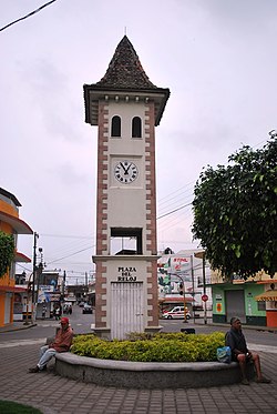
 French style clock tower at entrance of municipal seat | |
| Coordinates: 20°11′20″N 96°51′57″W / 20.18889°N 96.86583°W | |
| Country | |
| State | Veracruz |
| Founded | 19th century |
| Municipal Status | 2004 |
| Government | |
| • Municipal President | Rogelio Martin Capitaine Dominguez |
| Area | |
| • Municipality | 106.11 km2 (40.97 sq mi) |
| Population (2005)Municipality | |
| • Municipality | 29,277 |
| • Seat | 6,515 |
| • | 4,620 |
| Time zone | UTC-6 (Central (US Central)) |
| • Summer (DST) | UTC-5 (Central) |
| Postal code (of seat) | 93620 |
| Website | Web site |
San Rafael Municipality is a municipality located in the Mexican state of Veracruz. The municipal seat is San Rafael, Veracruz.
The economy of the municipality is primarily based on the primary sector. It produces bananas, lime, vanilla and other agricultural products. There is also a small tourism sector based on the area's immigrant culture. In the 19th century there was a wave of settlers from eastern France. As a result of this, a type of vernacular architecture emerged in the region, sometimes called the casas de las riberas del río Nautla (riverside houses of the Nautla River).
© MMXXIII Rich X Search. We shall prevail. All rights reserved. Rich X Search
