Back جبال سانتا آنا (سلسله جبليه فى الميكسيك) ARZ Santa Ana Mountains CEB Santa Ana Mountains Czech Santa-Ana-Gebirge German Sierra de Santa Ana Spanish Monts Santa Ana French സാന്താ അന പർവതനിരകൾ Malayalam Montanhas Santa Ana Portuguese Санта-Ана (хребет) Russian Santa Ana Mountains Swedish
| Santa Ana Mountains | |
|---|---|
 | |
| Highest point | |
| Peak | Santiago Peak |
| Elevation | 5,689 ft (1,734 m) |
| Coordinates | 33°42′38″N 117°32′03″W / 33.71056°N 117.53417°W |
| Dimensions | |
| Length | 61 mi (98 km) |
| Area | 2,104 sq mi (5,450 km2) |
| Geography | |
| Country | United States |
| State | California |
| Counties | Orange, Riverside and San Diego |
| Geology | |
| Age of rock | Triassic and Jurassic[1][2] |
| Type of rock | Metasedimentary[1] |
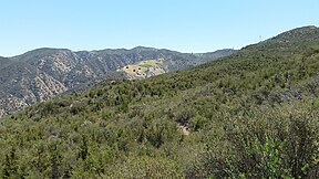
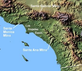
The Santa Ana Mountains are a short peninsular mountain range along the coast of Southern California in the United States. They extend for approximately 61 miles (98 km) southeast of the Los Angeles Basin largely along the border between Orange and Riverside counties.
- ^ a b Carol J. Stadum. "Geological History of Orange County". Irvine Valley College Department of Geological Sciences website. Retrieved February 21, 2008.
- ^ "State of California: California's Coastal Mountains". Archived from the original on December 22, 2007. Retrieved August 8, 2002.
© MMXXIII Rich X Search. We shall prevail. All rights reserved. Rich X Search
