Back جزر سانتا كروز Arabic Islles Santa Cruz AST Санта Крус (острови) Bulgarian Inizi Santa Cruz (Salomon) Breton Illes Santa Cruz Catalan Santa Cruz Islands CEB Santa Cruz (souostroví) Czech Santa Cruz-øerne Danish Santa-Cruz-Inseln German Santakrucowe kupy DSB


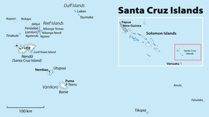
The Santa Cruz Islands is an archipelago in the Pacific Ocean, part of Temotu Province of the Solomon Islands. They lie approximately 250 miles (220 nmi; 400 km) to the southeast of the Solomon Islands archipelago. The Santa Cruz Islands lie just north of the archipelago of Vanuatu, and are considered part of the Vanuatu rain forests ecoregion.
© MMXXIII Rich X Search. We shall prevail. All rights reserved. Rich X Search