Back قرية شاغتيكوك (نيويورك) Arabic قرية شاجتيكوك ARZ اسکتیکوک (روستا)، نیویورک AZB Schaghticoke Catalan Schaghticoke (Village, New York) German Schaghticoke (villa) Spanish اسکتیکوک (روستا)، نیویورک Persian Schaghticoke French Schaghticoke (vohitra), New York Malagasy Schaghticoke (hrabstwo Rensselaer) Polish
Schaghticoke, New York | |
|---|---|
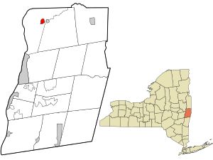
 Location in Rensselaer County and the state of New York. | |
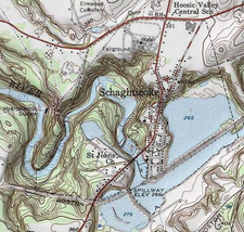
 USGS topographical map with the village | |
| Coordinates: 42°53′58″N 73°35′10″W / 42.89944°N 73.58611°W | |
| Country | United States |
| State | New York |
| County | Rensselaer |
| Area | |
| • Total | 0.99 sq mi (2.57 km2) |
| • Land | 0.76 sq mi (1.96 km2) |
| • Water | 0.23 sq mi (0.61 km2) |
| Elevation | 358 ft (109 m) |
| Population (2020) | |
| • Total | 527 |
| • Density | 695.25/sq mi (268.40/km2) |
| Time zone | UTC-5 (Eastern (EST)) |
| • Summer (DST) | UTC-4 (EDT) |
| ZIP code | 12154 |
| Area code | 518 |
| FIPS code | 36-65475 |
| GNIS feature ID | 0964566 |
Schaghticoke is a village in Rensselaer County, New York, United States. The population was 592 at the 2010 census.
During the colonial period of 1640-1750, this area was occupied by a mixed group of Native Americans — Mohicans, who were local, and remnants of numerous New England tribes who had migrated west away from European encroachment and warfare.
The Village of Schaghticoke is in the Town of Schaghticoke, near the eastern town line. Schaghticoke is west of the Village of Valley Falls.
- ^ "ArcGIS REST Services Directory". United States Census Bureau. Retrieved September 20, 2022.
© MMXXIII Rich X Search. We shall prevail. All rights reserved. Rich X Search
