Back Segovia AN شقوبية Arabic سيجوڤيا ARZ Segovia AST Seqoviya Azerbaijani Segovia, Espanya BCL Сеговія Byelorussian Сэговія BE-X-OLD Сеговия Bulgarian Segovia Breton
Segovia | |
|---|---|
 Location of Segovia | |
| Coordinates: 40°56′53″N 4°7′6″W / 40.94806°N 4.11833°W | |
| Country | Spain |
| Autonomous community | Castile and León |
| Province | Segovia |
| Government | |
| • Mayor | Clara Martín García (PSOE) |
| Area | |
• Total | 163.59 km2 (63.16 sq mi) |
| Elevation | 1,005 m (3,297 ft) |
| Population (2018)[1] | |
• Total | 51,683 |
| • Density | 320/km2 (820/sq mi) |
| Demonym | Segovian |
| Time zone | UTC+1 (CET) |
| • Summer (DST) | UTC+2 (CEST) |
| Postal code | 40001-40006 |
| Website | Official website |
Segovia (/sɪˈɡoʊviə/ sig-OH-vee-ə,[2] US also /seɪˈ-/ say-GOH-,[3] Spanish: [seˈɣoβja] ⓘ) is a city in the autonomous community of Castile and León, Spain. It is the capital and most populated municipality of the Province of Segovia. Segovia is located in the Inner Plateau of the Iberian Peninsula, near the northern slopes of the Sistema Central mountain range. Housing is nestled on a bend of the Eresma river.
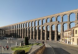
The city is famous for its historic buildings including three main landmarks: its midtown Roman aqueduct, its cathedral (one of the last ones to be built in Europe following a Gothic style), and the Alcázar of Segovia (a fortress). The city center was declared a World Heritage Site by UNESCO in 1985.
- ^ Municipal Register of Spain 2018. National Statistics Institute.
- ^ "Segovia". Collins English Dictionary. HarperCollins. Retrieved 26 September 2014.
- ^ "Segovia". Merriam-Webster.com Dictionary. Merriam-Webster. Retrieved 1 July 2019.
© MMXXIII Rich X Search. We shall prevail. All rights reserved. Rich X Search


