Back Selenga Afrikaans نهر سيلينجا Arabic نهر سيلينجا ARZ Selenqa çayı Azerbaijani سلنقا چایی AZB Селенга Byelorussian Селенга Bulgarian সেলেংগা নদী Bengali/Bangla Selenga BS Сэлэнгэ мүрэн BXR
| Selenga Selenge | |
|---|---|
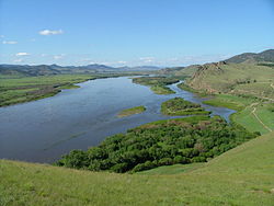
 Selenga River in Russia | |
 | |
| Native name | |
| Location | |
| Country | Russia, Mongolia |
| Physical characteristics | |
| Source | Delgermörön |
| 2nd source | Ider |
| Source confluence | Olon Golyn Bilchir |
| • location | Khövsgöl, Mongolia |
| • coordinates | 49°15′40″N 100°40′45″E / 49.26111°N 100.67917°E |
| Mouth | Lake Baikal |
| Length | 992 km (616 mi) |
| Basin size | 447,000 km2 (173,000 sq mi) |
| Discharge | |
| • location | Ust-Kyakhta |
| • average | 284 m3/s (10,000 cu ft/s) |
| • minimum | 23 m3/s (810 cu ft/s)February |
| • maximum | 601 m3/s (21,200 cu ft/s)August |
| Basin features | |
| Progression | Lake Baikal→ Angara→ Yenisey→ Kara Sea |
| Tributaries | |
| • right | Uda |
| Basin coordinates | 46-52 degrees N 96-109 degrees E |

The Selenga or Selenge (/sɛlɛŋˈɡɑː/[1] Mongolian: Сэлэнгэ мөрөн, romanized: Selenge mörön; Buryat: Сэлэнгэ гол / Сэлэнгэ мүрэн, romanized: Selenge gol / Selenge müren; Russian: Селенга́, IPA: [sʲɪlʲɪnˈɡa]) is a major river in Mongolia and Buryatia, Russia. Originating from its headwater tributaries, the Ider and the Delger mörön, it flows for 992–1,024 kilometres (616–636 mi)[2][3][4] before draining into Lake Baikal. The Selenga therefore makes up the most distant headwaters of the Yenisey-Angara river system.
Carrying 935 cubic metres per second (33,000 cu ft/s) of water into Lake Baikal, it makes up almost half of the riverine inflow into the lake, and forms a wide delta of 680 square kilometres (260 sq mi) when it reaches the lake.
Periodic annual floods are a feature of the Selenga River. The floods can be classified as “ordinary”, “large” or “catastrophic” based on the degree of impact. Of the twenty-six documented floods that occurred between 1730 and 1900, three were “catastrophic”. The three “catastrophic” floods were the floods of 1830, 1869 and 1897.
The Selenga River basin is a semi-arid region that is 280,000 square kilometres (110,000 sq mi) in area. It is part of the Arctic Ocean Basin and is located in northern Mongolia. Stone implement artifacts found on the Selenga River at the end of the 19th century have been used to form a link between Native Americans and their ancestors in East Asia. The climate of the Selenga basin is influenced by a powerful Siberian anti-cyclone. The weather consists of harsh winters and warm summers, with the river freezing from November to April.
The Selenga River delta is a Ramsar site, surrounded by marshlands. Found in the administrative region of the Republic of Buryatia, the wetlands are the habitat of a large number of threatened and endemic species, including the Siberian Baikal sturgeon and over 170 species of birds. The Selenge-Orkhon forest steppe includes the areas of the Orkhon and Selenge river basins. The region has scattered forests and extensive mountain ranges.
River modifications like the Irkutsk Hydroelectric Power Station have affected the environment of the Selenga Delta, causing it to become waterlogged. Activities including mining, agriculture, breeding and dumping of wastewater have also affected the environment of the river. There has been an observed degradation of water quality from these anthropogenic factors. Natural factors like erosion processes and weathering have also contributed to the decline in water quality.
The proposed Shuren Hydropower Plant Project was protested against by environmental groups because of the potential ecological ramifications it would have on the Selenga Delta. The reasons cited included potential disruption to the flow of the river and the breeding grounds of endemic fish species in Lake Baikal.
- ^ "Selenga", Dictionary.com
- ^ H. Barthel, Mongolei-Land zwischen Taiga und Wüste, Gotha 1990, p.34f
- ^ "Сэлэнгэ мөрөн". www.medeelel.mn. Archived from the original on December 5, 2012. Retrieved July 16, 2007.
- ^ Селенга in the Great Soviet Encyclopedia, 1969–1978 (in Russian)
© MMXXIII Rich X Search. We shall prevail. All rights reserved. Rich X Search