Back Shanlin German Chham-lìm-khî HAK Distretto di Shanlin Italian 杉林区 Japanese 산린구 Korean Shanlin Polish Sam Lâm Vietnamese 杉林區 Chinese 杉林區 ZH-CLASSICAL Sam-nâ-khu ZH-MIN-NAN
23°00′02″N 120°33′45″E / 23.000432°N 120.562538°E
Shanlin
杉林區 | |
|---|---|
| Shanlin District [1] | |
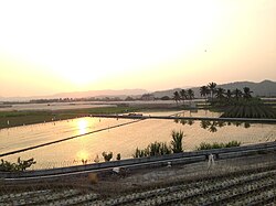
 The sunset in Shanlin. | |
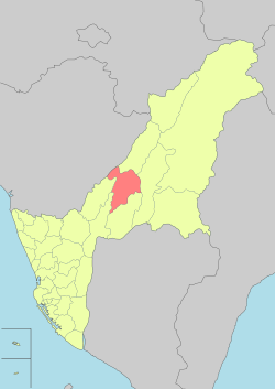
 Shanlin District in Kaohsiung City | |
| Country | Taiwan |
| Region | Southern Taiwan |
| Population (October 2023) | |
| • Total | 10,961 |
| Website | shanlin |
Shanlin District (Chinese: 杉林區; Hanyu Pinyin: Shānlín Qū; Tongyong Pinyin: Shanlín Cyu; Wade–Giles: Shanlin Ch'ü; Taiwanese: Sam-nâ-khu ), formerly known as Lâm-á-sian (楠梓仙) before 1901, later named Suannsamna (山杉林),[2] is a suburban district of Kaohsiung in southern Taiwan.
Shanlin borders Jiasian District to the north, Liougui District to the east, and is adjacent to Meinong District and Cishan District to the south. It shares its western border with Neimen District and connects to Nanhua District in Tainan City to the northwest.
The majority of the district's residents are Hakka people, constituting approximately 63% of the total population, with additional villages of Hoklo and indigenous Taivoan people.
- ^ "Glossary of Names for Admin Divisions" (PDF). placesearch.moi.gov.tw. Ministry of Interior of the ROC. Archived from the original (PDF) on 19 August 2015. Retrieved 12 June 2015.
- ^ 阿凡端 (2017-11-11). 高雄~楠梓仙溪白水泉瀑布+月眉黃家夥房+向日葵迷宮花田 [Kaohsiung ~ Nanzih Xianxi Bai Shui Quan Waterfall + Yue Mei Huang Jia Huo House + Sunflower Maze Flower Field]. 阿凡端◎私房景點. Retrieved 2023-11-17.
© MMXXIII Rich X Search. We shall prevail. All rights reserved. Rich X Search