Back شارون، کانتیکت AZB Sharon (Connecticut) Catalan Шарон (Коннектикут) CE Sharon (lungsod sa Tinipong Bansa, Connecticut) CEB Sharon (Connecticut) Spanish Sharon (Connecticut) Estonian Sharon (Connecticut) Basque Sharon (Connecticut) French Sharon, Connecticut HT Sharon (Connecticut) Italian
This article needs additional citations for verification. (April 2021) |
Sharon, Connecticut | |
|---|---|
| Town of Sharon | |
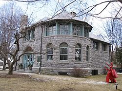
 Hotchkiss Memorial Library | |
| Coordinates: 41°52′N 73°27′W / 41.867°N 73.450°W | |
| Country | |
| U.S. state | |
| County | Litchfield |
| Region | Northwest Hills |
| Incorporated | 1739 |
| Named for | Sharon plain |
| Government | |
| • Type | Selectman-town meeting |
| • First selectman | Brent M. Colley (R) |
| • Selectman | Dale Jones (R) |
| • Selectman | Jessica K. Fowler (D) |
| Area | |
| • Total | 59.6 sq mi (154.3 km2) |
| • Land | 58.8 sq mi (152.2 km2) |
| • Water | 0.8 sq mi (2.1 km2) |
| Elevation | 1,135 ft (346 m) |
| Population (2020) | |
| • Total | 2,680 |
| • Density | 45/sq mi (17/km2) |
| Time zone | UTC−5 (Eastern) |
| • Summer (DST) | UTC−4 (Eastern) |
| ZIP code | 06069 |
| Area code(s) | 860/959 |
| FIPS code | 09-005-67960 |
| GNIS feature ID | 213503 |
| Website | www |
Sharon is a town in Litchfield County, Connecticut, United States, in the northwest corner of the state. At the time of the 2020 census, the town had a total population of 2,680.[1] The town is part of the Northwest Hills Planning Region. The ZIP code for Sharon is 06069. The urban center of the town is the Sharon census-designated place, with a population of 729 at the 2010 census.[2]
- ^ "Census - Geography Profile: Sharon town, Litchfield County, Connecticut". United States Census Bureau. Retrieved December 21, 2021.
- ^ "Geographic Identifiers: 2010 Census Summary File 1 (G001), Sharon CDP, Connecticut". American FactFinder. U.S. Census Bureau. Archived from the original on February 13, 2020. Retrieved October 15, 2019.
© MMXXIII Rich X Search. We shall prevail. All rights reserved. Rich X Search


