Back شلتر ايلند ARZ Шелтер-Айленд (Нью-Йорк) CE Shelter Island (lungsod) CEB Shelter Island German Shelter Island (Nueva York) Spanish Shelter Island Estonian جزیره پناهگاه، نیویورک Persian Shelter Island (New York) Finnish Shelter Island French Shelter Island, New York HT
Shelter Island, New York | |
|---|---|
| Town of Shelter Island | |
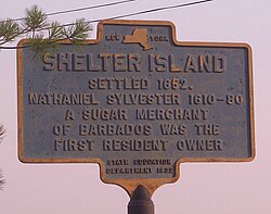
 A historic marker plaque on Shelter Island explaining the history of the area. | |
 Location in Suffolk County | |
| Coordinates: 41°4′41″N 72°21′3″W / 41.07806°N 72.35083°W | |
| Country | |
| State | |
| County | Suffolk |
| Government | |
| • Type | Civil Township |
| • Town Supervisor | Gerry Siller (D)[1] |
| Area | |
| • Total | 29.11 sq mi (75.39 km2) |
| • Land | 12.19 sq mi (31.58 km2) |
| • Water | 16.92 sq mi (43.82 km2) |
| Elevation | 56 ft (17 m) |
| Population (2010) | |
| • Total | 3,253 |
| • Estimate (2016)[3] | 2,413 |
| • Density | 266.86/sq mi (103.01/km2) |
| Time zone | UTC-5 (Eastern (EST)) |
| • Summer (DST) | UTC-4 (EDT) |
| ZIP Codes | 11964, 11965 |
| Area code | 631 |
| FIPS code | 36-103-66839 |
| GNIS feature ID | 0965037 |
| Website | www |
Shelter Island is an island town in Suffolk County, New York, United States, near the eastern end of Long Island. The population was 3,253 at the 2020 United States census.
- ^ "Town Supervisor". Town of Shelter Island.
- ^ "2016 U.S. Gazetteer Files". United States Census Bureau. Retrieved July 5, 2017.
- ^ "Population and Housing Unit Estimates". Retrieved June 9, 2017.
© MMXXIII Rich X Search. We shall prevail. All rights reserved. Rich X Search


