Back شرمان، کانتیکت AZB Sherman (Connecticut) Catalan Шерман (Коннектикут) CE Sherman (lungsod sa Tinipong Bansa, Connecticut) CEB Sherman, Connecticut Welsh Sherman (Connecticut) Spanish Sherman (Connecticut) Basque شرمن، کنتیکت Persian Sherman (Connecticut) French Sherman, Connecticut HT
Sherman, Connecticut | |
|---|---|
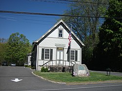
 1886 Town Hall | |
| Coordinates: 41°35′N 73°30′W / 41.583°N 73.500°W | |
| Country | |
| U.S. state | |
| County | Fairfield |
| Region | Western CT |
| Incorporated | 1802 |
| Government | |
| • Type | Selectman-town meeting |
| • First selectman | Don Lowe (D) |
| • Selectman | Joel Bruzinski (D) |
| • Selectman | Bob Ostrosky (R) |
| Area | |
| • Total | 23.4 sq mi (60.6 km2) |
| • Land | 21.8 sq mi (56.5 km2) |
| • Water | 1.6 sq mi (4.0 km2) |
| Elevation | 466 ft (142 m) |
| Population (2020) | |
| • Total | 3,527 |
| • Density | 150/sq mi (58/km2) |
| Time zone | UTC-5 (Eastern) |
| • Summer (DST) | UTC-4 (Eastern) |
| ZIP Code | 06784 |
| Area code(s) | 860/959 |
| FIPS code | 09-68310 |
| GNIS feature ID | 0213505 |
| Website | www |
Sherman is the northernmost and least populous town of Fairfield County, Connecticut, United States. The population was 3,527 at the 2020 census.[1] The town is part of the Western Connecticut Planning Region. The town was formed in 1802 from the northern part of New Fairfield. It is named for Roger Sherman, the only person who signed all four founding documents of the United States of America.[2] He also had a cobblers shop in the north end of town which has been reconstructed behind the Northrup House in the center of town.
The Appalachian Trail goes through the northern end of Sherman. Part of Squantz Pond is in the town.
Sherman is a popular weekend retreat for New York City residents, with about a third of its residents weekenders. The town is located 62 miles (100 km) northeast of New York City, making it part of the New York metropolitan area.[3]
Sherman has one area on the National Register of Historic Places: the Sherman Historic District, bounded roughly by the intersection of Old Greenswood Road and Route 37, northeast past the intersection of Route 37 East and Route 39 North and Sawmill Road. The district was added to the National Register on August 31, 1991.
Sherman is the only town in Fairfield County in the 860 area code; the remainder of the county is served by the area code 203/area code 475 overlay.
- ^ "Census - Geography Profile: Sherman town, Fairfield County, Connecticut". United States Census Bureau. Retrieved December 21, 2021.
- ^ The Connecticut Magazine: An Illustrated Monthly. Connecticut Magazine Company. 1903. p. 334.
- ^ Hodara, Susan (November 28, 2018). "Sherman, Conn.: A Quiet Town with a Medley of People". The New York Times.
© MMXXIII Rich X Search. We shall prevail. All rights reserved. Rich X Search


