Back Pulo Shiashkotan ACE Sjiasjkotan Afrikaans Shiashkotan AST Şiaşkotan Azerbaijani Шыяшкотан Byelorussian Xiaixkotan Catalan Ostrov Shiashkotan CEB Šiaškotan Czech Schiaschkotan German Shiashkotan Spanish
This article includes a list of general references, but it lacks sufficient corresponding inline citations. (March 2012) |
Native name: Шиашкотан 捨子古丹島 | |
|---|---|
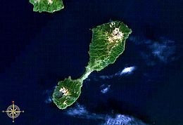
 Landsat view of Shiashkotan Island | |
 | |
| Geography | |
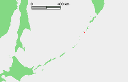
| Location | Sea of Okhotsk |
| Coordinates | 48°49′N 154°6′E / 48.817°N 154.100°E |
| Archipelago | Kuril Islands |
| Area | 122 km2 (47 sq mi) |
| Highest elevation | 944 m (3097 ft) |
| Highest point | Pik Sinarka |
| Administration | |
Russia | |
| Demographics | |
| Population | 0 |
| Ethnic groups | Ainu (formerly) |

Shiashkotan (Russian: Шиашкотан) (Japanese: 捨子古丹島; Shasukotan-tō) is an uninhabited volcanic island near the center of the Kuril Islands chain in the Sea of Okhotsk in the northwest Pacific Ocean, separated from Ekarma by the Ekarma Strait. Its name is derived from the Ainu language, from “Konbu village”.

© MMXXIII Rich X Search. We shall prevail. All rights reserved. Rich X Search