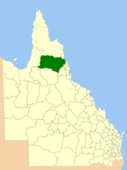
| Shire of Mareeba Queensland | |||||||||||||||
|---|---|---|---|---|---|---|---|---|---|---|---|---|---|---|---|
 Location within Queensland | |||||||||||||||
| Population | 22,858 (2021 census)[1] | ||||||||||||||
| • Density | 0.427324/km2 (1.10676/sq mi) | ||||||||||||||
| Established | 2014 | ||||||||||||||
| Area | 53,491 km2 (20,653.0 sq mi)[2] | ||||||||||||||
| Mayor | Angela Toppin | ||||||||||||||
| Council seat | Mareeba | ||||||||||||||
| Region | Far North Queensland | ||||||||||||||
 | |||||||||||||||
| Website | Shire of Mareeba | ||||||||||||||
| |||||||||||||||
The Shire of Mareeba is a local government area at the base of Cape York Peninsula in Far North Queensland, inland from Cairns. The shire, administered from the town of Mareeba, covered an area of 53,491 square kilometres (20,653.0 sq mi), and existed as a local government entity from 1879 until 2008, when it amalgamated with several councils in the Atherton Tableland area to become the Tablelands Region.
On 20 March 2013, Mareeba residents voted in favour of a proposal to reverse the amalgamation and to re-establish Mareeba Shire. The new Mareeba Shire was re-established on 1 January 2014.
In the 2021 census, the Shire of Mareeba had a population of 22,858 people.[1]
- ^ a b Cite error: The named reference
Census2021was invoked but never defined (see the help page). - ^ "3218.0 – Regional Population Growth, Australia, 2017-18: Population Estimates by Local Government Area (ASGS 2018), 2017 to 2018". Australian Bureau of Statistics. Australian Bureau of Statistics. 27 March 2019. Retrieved 25 October 2019. Estimated resident population, 30 June 2018.
© MMXXIII Rich X Search. We shall prevail. All rights reserved. Rich X Search
