Back Plantagenet Shire CEB Plantagenet Shire German Comté de Plantagenet French Contea di Plantagenet Italian Shire of Plantagenet Dutch Plantagenet Shire Swedish
| Shire of Plantagenet Western Australia | |||||||||||||||
|---|---|---|---|---|---|---|---|---|---|---|---|---|---|---|---|
 Plantagenet shire offices, 2018 | |||||||||||||||
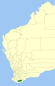
 Location in Western Australia | |||||||||||||||
 | |||||||||||||||
| Population | 5,388 (LGA 2021)[1] | ||||||||||||||
| Established | 1871 | ||||||||||||||
| Area | 4,792 km2 (1,850.2 sq mi) | ||||||||||||||
| Shire President | Chris Pavlovich | ||||||||||||||
| Council seat | Mount Barker | ||||||||||||||
| Region | Great Southern | ||||||||||||||
| State electorate(s) | Blackwood-Stirling | ||||||||||||||
| Federal division(s) | O'Connor | ||||||||||||||
 | |||||||||||||||
| Website | Shire of Plantagenet | ||||||||||||||
| |||||||||||||||
The Shire of Plantagenet is a local government area in the Great Southern region of Western Australia, managed from the town of Mount Barker, 360 kilometres (224 mi) south of Perth and 50 kilometres (31 mi) north of Albany. The shire covers an area of 4,792 square kilometres (1,850 sq mi)[2] and includes the communities of Narrikup, Rocky Gully, Kendenup and Porongurup.
The region is noted for agriculture, principally wheat, sheep (wool and meat), beef cattle, wine, canola and olives. Silviculture, especially plantations of Tasmanian blue gums (Eucalyptus globulus), was a major industry in the shire although some recent silviculture enterprises (Great Southern Plantations and Timbercorp)[3] have gone into receivership. Local tourist attractions include the Porongurup Range and Stirling Range, a museum based within the original police station, as well as other pioneer structures such as St Werburgh's Chapel.
- ^ Australian Bureau of Statistics (28 June 2022). "Plantagenet (Local Government Area)". Australian Census 2021 QuickStats. Retrieved 28 June 2022.
- ^ "Home » Shire of Plantagenet". Plantagenet.wa.gov.au. Retrieved 25 January 2022.
- ^ "Timbercorp - Home". Archived from the original on 28 July 2011. Retrieved 24 July 2011. Timbercorp
© MMXXIII Rich X Search. We shall prevail. All rights reserved. Rich X Search