Back Westonia (rehiyon) CEB Westonia Shire German Comté de Westonia French Contea di Westonia Italian Shire of Westonia Dutch Westonia Shire Swedish
| Shire of Westonia Western Australia | |||||||||||||||
|---|---|---|---|---|---|---|---|---|---|---|---|---|---|---|---|
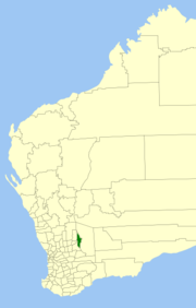
 Location in Western Australia | |||||||||||||||
 | |||||||||||||||
| Population | 248 (LGA 2021)[1] | ||||||||||||||
| Area | 3,304.4 km2 (1,275.8 sq mi) | ||||||||||||||
| Shire President | Karin Day | ||||||||||||||
| Council seat | Westonia | ||||||||||||||
| Region | Wheatbelt | ||||||||||||||
| State electorate(s) | Central Wheatbelt | ||||||||||||||
| Federal division(s) | Durack | ||||||||||||||
 | |||||||||||||||
| Website | Shire of Westonia | ||||||||||||||
| |||||||||||||||
The Shire of Westonia is a local government area in the eastern Wheatbelt region of Western Australia, about 310 kilometres (193 mi) east of Perth, the state capital. Its seat of government is the small town of Westonia.
Although the Shire of Westonia is located in the Wheatbelt region, it is at the eastern limit of land suitable for wheat growing. The most important industries of Westonia today are wheat and sheep, but historically it was a gold mining area.
- ^ Australian Bureau of Statistics (28 June 2022). "Westonia (Local Government Area)". Australian Census 2021 QuickStats. Retrieved 28 June 2022.
© MMXXIII Rich X Search. We shall prevail. All rights reserved. Rich X Search