Back Shrewsbury (Massachusetts) Catalan Шрусбери (Массачусетс) CE Shrewsbury (lungsod sa Tinipong Bansa, Massachusetts) CEB شروزبێری، ماساچووسیتس CKB Shrewsbury (Massachusetts) Czech Shrewsbury, Massachusetts Welsh Shrewsbury (Massachusetts) German Shrewsbury (Massachusetts) Spanish Shrewsbury (Massachusetts) Basque شروزبری، ماساچوست Persian
Shrewsbury, Massachusetts | |
|---|---|
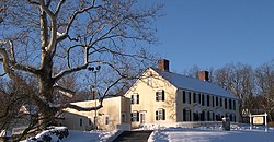
 Homestead of General Artemas Ward | |
 Location in Worcester County and the state of Massachusetts | |
| Coordinates: 42°17′45″N 71°42′48″W / 42.29583°N 71.71333°W | |
| Country | United States |
| State | Massachusetts |
| County | Worcester |
| Settled | 1722 |
| Incorporated | 1727 |
| Government | |
| • Type | Representative town meeting |
| • Town Manager | Kevin Mizikar |
| • Select Board | Beth N. Casavant John R. Samia Theresa H. Flynn Michelle K. Conlin Carlos A. Garcia |
| Area | |
| • Total | 21.7 sq mi (56.1 km2) |
| • Land | 20.7 sq mi (53.7 km2) |
| • Water | 0.9 sq mi (2.4 km2) |
| Elevation | 668 ft (204 m) |
| Population (2020) | |
| • Total | 38,325 |
| • Density | 1,851.4/sq mi (713.7/km2) |
| Time zone | UTC−5 (Eastern) |
| • Summer (DST) | UTC−4 (Eastern) |
| ZIP Code | 01545 |
| Area code | 508 / 774 |
| FIPS code | 69-60165 |
| GNIS feature ID | 619489 |
| Website | www.shrewsburyma.gov |
Shrewsbury (/ˈʃruzberi/ SHROOZ-bury) is a town in Worcester County, Massachusetts, United States. The population was 38,325 according to the 2020 United States Census, in nearly 15,000 households.[1]
Incorporated in 1727, Shrewsbury prospered in the 19th-century due to its proximity to Worcester, and from visitors to Lake Quinsigamond. The town is governed under the New England representative town meeting system, headed by the Town Manager and five-member elected Select Board.
- ^ "Census - Geography Profile: Shrewsbury town, Worcester County, Massachusetts". Retrieved September 5, 2023.
© MMXXIII Rich X Search. We shall prevail. All rights reserved. Rich X Search
