Back Sierra Madre (Filipinas) BCL Sierra Madre (Filipines) Catalan Sierra Madre Range (kabukiran sa Pilipinas, lat 16,34, long 121,94) CEB سیرا مادرێ (فلیپین) CKB Sierra Madre (Philippinen) German Sierra Madre (Filipinas) Spanish Sierra Madre (Philippines) French Sierra Madre (Filipina) ID Sierra Madre (Filipinas) ILO Sierra Madre (Filippine) Italian
| Sierra Madre | |
|---|---|
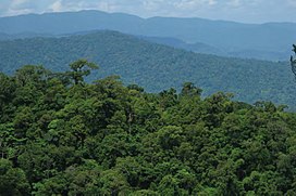
 View south of the northern Sierra Madre from the peak of Mount Cagua in Cagayan | |
| Highest point | |
| Peak | Mount Guiwan |
| Elevation | 1,915 m (6,283 ft) |
| Dimensions | |
| Length | 540 km (340 mi) North to south |
| Width | 56 km (35 mi) east to west |
| Area | 16,260 km2 (6,280 sq mi) |
| Geography | |
| Country | Philippines |
| Province | |
| Region | |
| Range coordinates | 16°3′N 121°35′E / 16.050°N 121.583°E |
| Borders on | Pacific Ocean |
The Sierra Madre is the longest mountain range in the Philippines. Spanning over 540 kilometers (340 mi), it runs from the province of Cagayan down to the province of Quezon, forming a north–south direction on the eastern portion of Luzon, the largest island of the archipelago. It is bordered by the Pacific Ocean to the east, Cagayan Valley to the northwest, Central Luzon to the midwest, and Calabarzon to the southwest. Some communities east of the mountain range, along the coast, are less developed and so remote that they could only be accessed by taking a plane or a boat.[1]
The country's largest protected area, the Northern Sierra Madre Natural Park, is situated at the northern part of the range in the province of Isabela. The park is in the UNESCO tentative list for World Heritage List inscription. Environmentalists, scholars, and scientists have been urging the government to include the other parks within the Sierra Madre mountains for a UNESCO site that would encompass the entire mountain range from Cagayan to Quezon.[2]
- ^ U.S. Coast and Geodetic Survey (1919). "United States Coast Pilot Philippine Islands Part 1", pg. 44. Government Printing Office, Washington.
- ^ Coursey, Oscar William (1903). History and Geography of the Philippine Islands. Educator School Supply Company.
© MMXXIII Rich X Search. We shall prevail. All rights reserved. Rich X Search
